Before the first mile on the road, our 17-day summer road trip began with weeks of planning and excitement. From mapping a route through canyons, cities, and coastlines to prepping our SUV with new tires and brakes, every detail mattered. We packed for the August heat — hiking shoes, water bottles, even USB fans — and booked family-friendly stays to keep each day comfortable. With the map ready and the car loaded, we couldn’t wait to see where the journey would take us.
Planning the Adventure
Every great journey begins long before the engine starts. Ours began with weeks of dreaming, mapping, and countless conversations about where the road would take us. For this 17-day summer road trip, planning became part of the excitement itself. We wanted more than a long drive — this had to be a journey that was comfortable, family-friendly, and filled with little discoveries along the way.
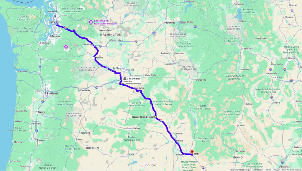
The route came first. From Redmond, WA, our path would wind through Boise and Twin Falls in Idaho, drop into Salt Lake City, and then on to the breathtaking landscapes of Bryce Canyon and Zion Canyon in Utah. From there, we’d head to the mighty Grand Canyon in Arizona, continue on to the dazzling lights of Las Vegas, pause in Bakersfield for a driving break, enjoy family time in San Mateo, CA, and then make our way home with a restful stop in Roseburg, Oregon. Just tracing the names on the map felt like sketching out a giant story waiting to unfold.
Because it was August — the peak of summer heat — we knew preparation was key. From desert canyons to city streets, high temperatures would be our constant companion. We packed smart: sturdy hiking shoes, plenty of reusable water bottles, a large growler for refills, and for the ladies, handy little USB rechargeable fans that became lifesavers in the midday sun.
The car was just as important as the luggage. Our SUV went in for a full check-up: new tires, new brakes (both due), and all fluids topped up. Knowing the vehicle was ready for long stretches of highway — and the occasional desert climb — gave us peace of mind. The last thing we wanted was a breakdown in the middle of nowhere.
We also mapped the return trip carefully, knowing it would be a highlight of its own. The drive would take us past the shimmering waters of Lake Shasta, the snow-capped majesty of Mount Shasta, over the winding Siskiyou Pass, and through the charming town of Ashland, Oregon, before ending the day in Roseburg. That leg alone promised as much beauty and adventure as any of our destination stops.
Hotels became the next puzzle — a balance of comfort, budget, and convenience. We chose places close to the sights, family-friendly, and easy to check into after a long day’s drive. Since we agreed to drive only during the day (no more than 7–8 hours per stretch), our evenings would be left for relaxing, unwinding, and soaking up each destination.
Still, we left room for spontaneity. One of the joys of a road trip is the unexpected, and we promised ourselves to pull over at scenic vista points, quirky roadside attractions, or any little detour that caught our curiosity. After all, some of the best memories are the ones you don’t plan
Summer Road Trip Essentials
👟 Hiking shoes
💧 Reusable water bottles
🥤 Large water growler
🌬️ USB rechargeable fans
🧢 Caps & sunglasses
🧴 Sunscreen
🍿 Snacks for the car
Car Prep Essentials
- ✅ Full dealer inspection
- 🛞 New tires
- 🛑 New brakes
- 💧 Fluids topped up (oil, coolant, windshield washer, brake fluid)
- 🔋 Battery check
- 🛠️ Spare tire, jack & tools
- 🚨 Emergency kit (jumper cables, flashlight, first aid kit)
- 🧴 Cleaning wipes & trash bags
- 🛡️ AAA Plus Membership
Road Trip Itinerary at a Glance
Starting Point: Redmond, WA
1️⃣ Boise, ID – Overnight stay
2️⃣ Twin Falls, ID – Overnight stay
3️⃣ Salt Lake City, UT – Overnight stay
4️⃣ Bryce Canyon, UT – Overnight stay
5️⃣ Zion Canyon (Springdale, UT) – 2 nights
6️⃣ Grand Canyon, AZ – 2 nights
7️⃣ Las Vegas, NV – 2 nights
8️⃣ Bakersfield, CA – Overnight stay (driving break)
9️⃣ San Mateo, CA – 4 nights
🔄 Return Drive – through Redding, Lake Shasta, Mount Shasta, Siskiyou Pass, Ashland, OR
🔟 Roseburg, OR – Overnight stay
🏡 Home: Redmond, WA
With the route mapped, hotels booked, SUV road-trip ready, and our bags packed with summer essentials, all that was left was to hit the open road. The countdown had ended — Day 1 was here. Our journey from Redmond to Boise was about to begin, and the adventure of a lifetime was finally rolling into motion.
Day 1: Redmond to Boise – Distance 491 miles
It was 9:30 AM when we finally pulled out of Redmond—cars loaded, excitement high, and Boise firmly on our minds. Our first stop was Costco in Issaquah to top off the tank—premium gas cost $4.799 per gallon, a good benchmark for the road ahead.
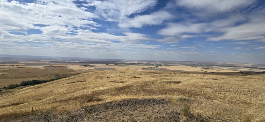
The journey began with a moody, rainy trek over Snoqualmie Pass, where summer fog wrapped the mountains in mystery. After clearing some construction zones, I-90 smoothed out, leading us past Ellensburg and onto I-82. The changing scenery ushered us into Yakima Valley, where we paused at scenic overlooks to soak in the views.
By 12:30 PM, hunger led us to Taco Bell in Sunnyside, WA. This small city of around 16,000 sits in the heart of Yakima Valley, known for its sunny climate, vineyards, and hop farms—perfect for a casual meal amid agricultural charm.
Refreshed, we drove into Oregon, crossing the majestic Columbia River—a vital natural and historic boundary shaping the Pacific Northwest. Next, we entered Pendleton, where winding roads through the foothills of the Blue Mountains made the landscape feel cinematic. We pulled off at the Pendleton Vista for a few memorable snapshots.
Pendleton is a storied city that proudly calls itself “The Real West.” Nestled at the foothills of the Blue Mountains along the Umatilla River, it’s known for its rodeo heritage, the iconic Pendleton Woolen Mills, and vibrant cultural institutions.
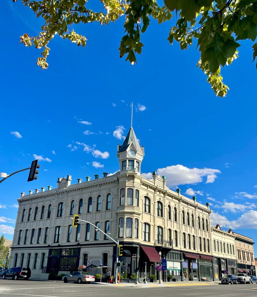
Our drive continued into Baker City, where we visited the exterior of the historic Geiser Grand Hotel—an Italian-Victorian beauty built in 1889 and once known as “the finest hotel between Portland and Salt Lake City.
‘
One of the interesting sign and meaningful sign, we noticed while driving on I-84 was 45th Parallel. It’s line of latitude that circles the Earth halfway between the Equator (0 degrees) and the North (90 Degrees). We were exactly halfway between the equator and the North Pole in terms of latitude.
A quick refresh at Albertsons Starbucks and refuel—premium gas was now $4.099 per gallon—got us ready for the final leg to Boise. Along the way, tech landmarks like Micron and Leidos hinted at our return to urban life.
We pulled into Simple Suites Hotel near Boise Airport around 7:30 PM. Located at 2909 W Elder St, Boise, ID 83705, it offered clean, comfortable rooms with thoughtful amenities like a snack shop, fitness center, EV charging, and convenient airport access—just what we needed after a full day of driving.
Summary Day 1
🥾 Day Essentials
- Waterproof layers for Snoqualmie Pass
- Water, snacks, and a playlist for the road
- Camera for impromptu views at scenic spots
- Be mindful of time zones (Pacific vs Mountain Time in eastern OR)
Road Notes
- 9:30 AM departure from Redmond
- Foggy and moody Snoqualmie Pass
- Scenic stops in Yakima Valley
- Lunch in Sunnyside—a sunny wine-growing town in WA.
- Crossed the Columbia River into Oregon—a historic natural boundary.
- Pendleton: gateway to eastern Oregon’s rich Western heritage.
- Geiser Grand Hotel in Baker City—Victorian era landmark.
- Gas prices: Issaquah $4.799/gal, Baker City area $4.099/gal
- Final stretch: Boise tech corridor
- Checked-in to Hotel around 7:30pm.
Our Highlights
- Foggy Snoqualmie Pass setting a dramatic tone
- Panoramic Yakima Valley vistas
- A taste of the Old West in Pendleton
- Visual delight in the architecture of the Geiser Grand Hotel
- Modern comforts at Simple Suites Hotel were a welcome end to Day 1
Day 2: Exploring Boise & Twin Falls
After a home-cooked dinner prepared by my wife the night before at Simple Suites (thanks to the in-room kitchen), we had an early night’s rest. The next morning, a light breakfast was enough to get us going. Starting the day unhurried felt right after the long drive on Day 1. By 10:30 AM, we were checked out and ready to explore some of Boise’s highlights.
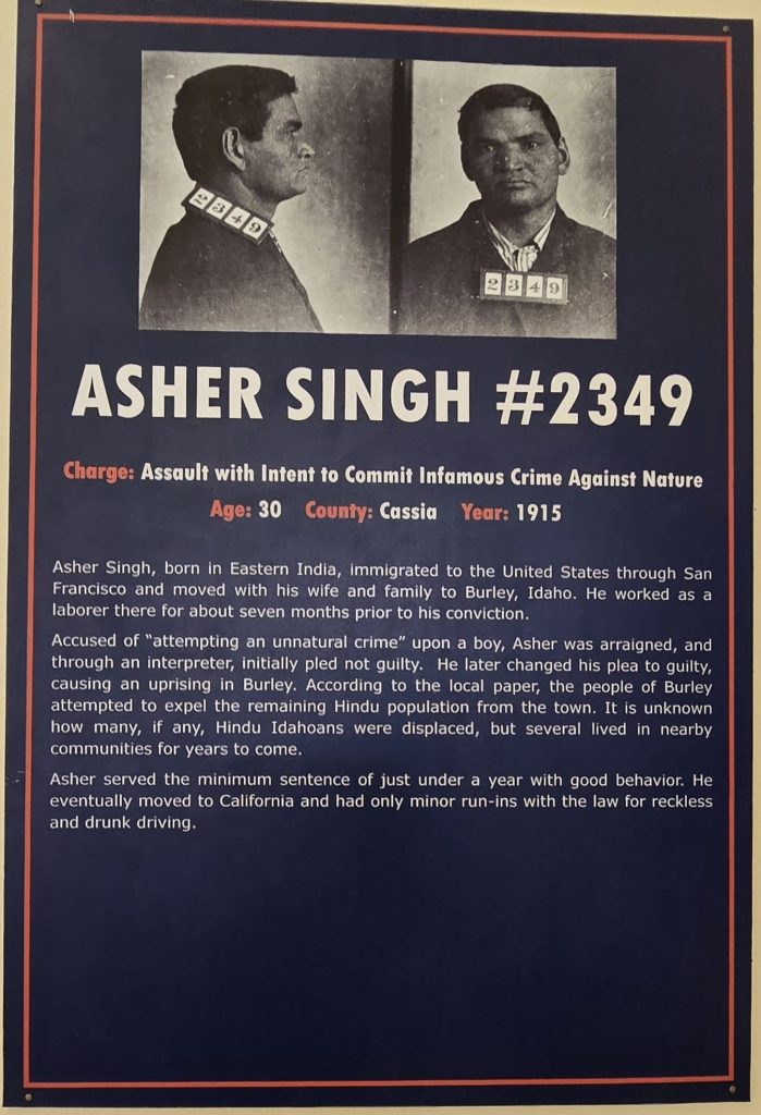
Old Idaho State Penitentiary
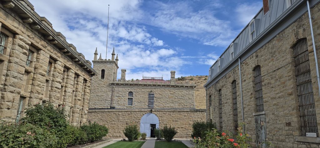
Our first stop was the Old Idaho State Penitentiary, which we reached around 11:00 AM. Parking was plentiful, and adult tickets cost just $8.00.
Exhibits of Interest
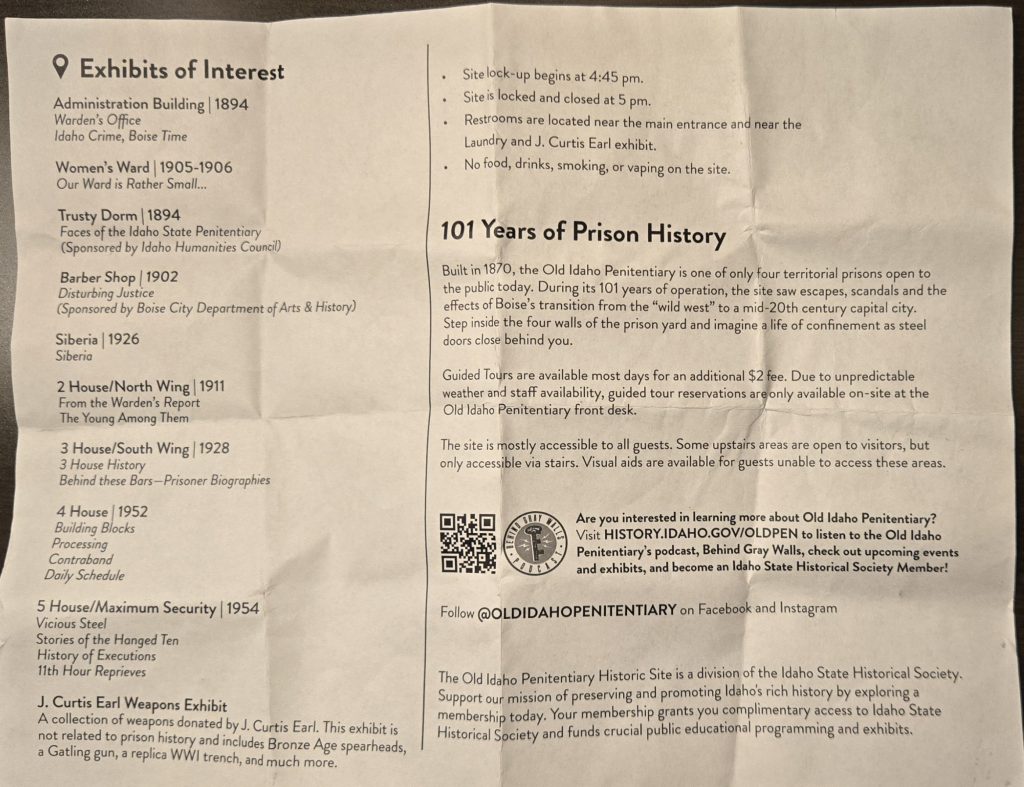
The penitentiary opened in 1872 and housed inmates for over 100 years until its closure in 1973 due to prison riots that burned some parts of the buildings. Built largely by prisoners from nearby sandstone, the prison once held some of the West’s most notorious criminals. As we explored the grounds, we stepped into cell blocks, solitary confinement areas known as “Siberia,” the laundry room, shower facilities, kitchen and dining, gallows, and even the women’s ward. Each space carried echoes of the past, and the exhibits revealed fascinating stories of prison life, escapes, and daily struggles. Spending a couple of hours wandering its corridors gave us a vivid glimpse into Idaho’s history of justice and punishment.

Idaho State Capitol Building
Next, we drove downtown to the Idaho State Capitol Building. Completed in 1920, the Capitol is a striking example of Renaissance Revival architecture, designed by J.E. Tourtellotte and Charles Hummel. The sandstone exterior was quarried from nearby Table Rock, while the interior features four kinds of marble from around the world. The most unique feature? It’s the only U.S. state capitol heated by a geothermal system, tapping into hot water beneath the city.
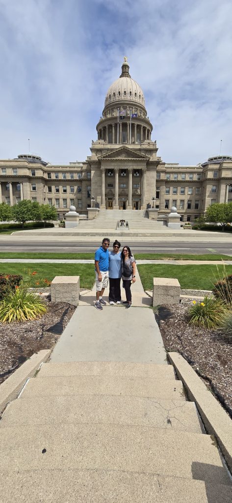
Since it was Saturday and the legislature wasn’t in session, parking was easy to find. We spent about 40 minutes taking photos inside and outside, admiring its stately dome and beautifully carved details.
By now, it was lunchtime, so we stopped at Mod Pizza, conveniently located near the Capitol. With parking nearby, it was a quick and tasty meal—just what we needed before hitting the road again.
Boise to Twin Falls – 132 Miles
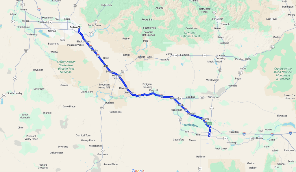
By 2:20 PM, we were back on I-84, heading southeast toward Twin Falls, about two hours away. The drive revealed a sunnier side of Idaho—rolling hills, wide-open skies, and distant mountains that seemed to follow us along the way.
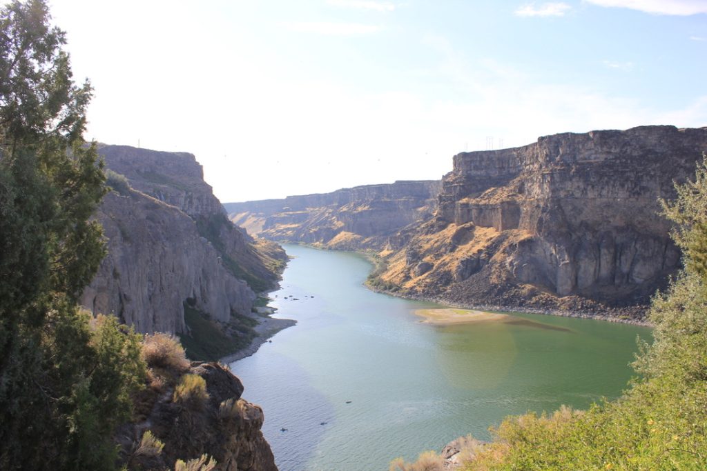
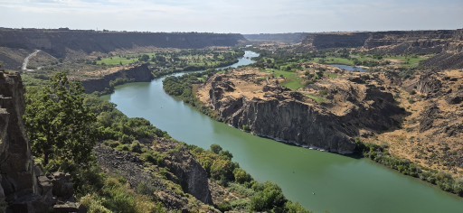
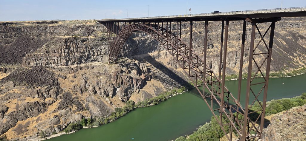
Our first stop in Twin Falls was the Visitor Center, located right next to the iconic Perrine Bridge. Completed in 1976, this 1,500-foot span soars nearly 500 feet above the Snake River Canyon, making it one of the highest bridges in the U.S. It’s also famous as one of the only man-made structures where BASE jumping is allowed year-round. Standing at its edge, we admired the bridge’s engineering and the breathtaking canyon carved by the Snake River over millennia.
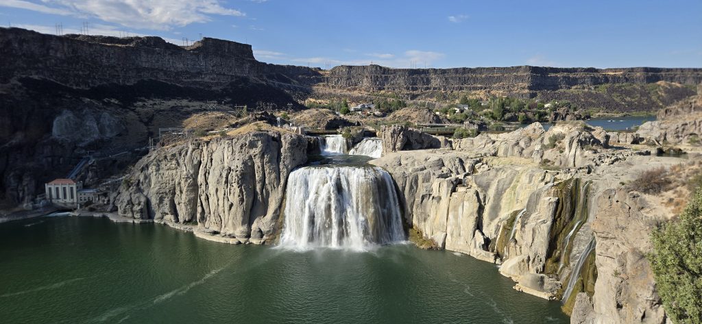
Shoshone Falls – “Niagara of the West”
From there, we continued to Shoshone Falls, arriving around 5:45 PM. Entry was just $5.00 per vehicle. Often called the Niagara of the West, Shoshone Falls is actually taller than Niagara at 212 feet high and nearly 900 feet wide. Even in peak summer, the water flow was majestic, and it was easy to imagine how thunderous it must be during spring runoff. We spent time capturing photos and simply soaking in the grandeur of the falls framed by the basalt canyon walls.
Rest for the Night
By early evening, we checked into the SureStay Best Western Hotel in Twin Falls (1260 Blue Lakes Blvd N, Twin Falls, ID 83301). The accommodations were basic and not particularly impressive, though the room did include a microwave and refrigerator, which allowed us to warm up some tasty homemade meals we had packed. After a full day of exploring, it was time to rest and recharge for Day 3.
Summary Day 2
🥾 Day Essentials
- Comfortable walking shoes (for exploring penitentiary & Capitol)
- Camera for capturing Shoshone Falls & Snake River Canyon
- Water bottles for the road trip
- Light layers for varying weather
📌 Road Notes
- 10:30 AM checkout from Boise
- Old Idaho State Penitentiary (opened 1872, closed 1973; “Siberia” solitary cells, women’s ward)
- Idaho State Capitol (completed 1920, sandstone, geothermal heating system)
- Lunch at Mod Pizza near Capitol
- Scenic 2-hour drive on I-84 to Twin Falls
- Perrine Bridge (1976, 500 ft above Snake River Canyon, BASE jumping site)
- Shoshone Falls (212 ft high, 900 ft wide, taller than Niagara Falls; $5 entry)
- Hotel: SureStay Best Western, Twin Falls
💡 Our Highlights
- The eerie but fascinating feel of the penitentiary’s stone cells
- The elegance of Idaho’s Capitol building dome and marble halls
- The jaw-dropping scale of Perrine Bridge and the Snake River Canyon
- Watching the power of Shoshone Falls at sunset—truly unforgettable
Day 2 was the perfect mix of history, architecture, and natural beauty—from walking the haunted halls of an old prison to admiring the grandeur of the Capitol, and finally standing in awe at the edge of Shoshone Falls. It felt like we had experienced the heart of Idaho in just one day. With tired feet, full hearts, and a camera roll overflowing with memories, we settled into our hotel for the night, eager to see what Day 3 would bring.
Day 3: Twin Falls to Salt Lake City — From Desert Roads to Temple Square
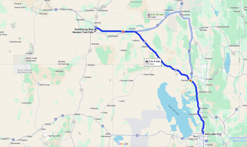
Waking up in Twin Falls after a day packed with history and waterfalls, we were excited to continue exploring southern Idaho and beyond. After a good night’s sleep and a light complimentary breakfast at the hotel, we packed our bags and set out for Salt Lake City, Utah, around 9:30 AM. By this point, we had already logged about 636 miles on our journey.
Road to Salt Lake City – Distance 220 Miles
Our first stop was to fill up at Costco Gas in Twin Falls, where premium was a refreshing $3.869 per gallon—a welcome drop compared to Washington and Oregon prices. With a full tank, we drove the 220 miles toward Salt Lake City via I-84. The scenery shifted between mountains, desert stretches, and smoky skies as we passed areas affected by wildfires. Eventually, the highway merged onto I-15, leading us closer to Utah’s capital.
Around 11:30 AM, we stopped for lunch at Olive Garden in Bountiful, conveniently located just 10 miles north of Salt Lake City right off the interstate. It was a perfect midway pause before the afternoon of sightseeing.
The Great Salt Lake & Antelope Island
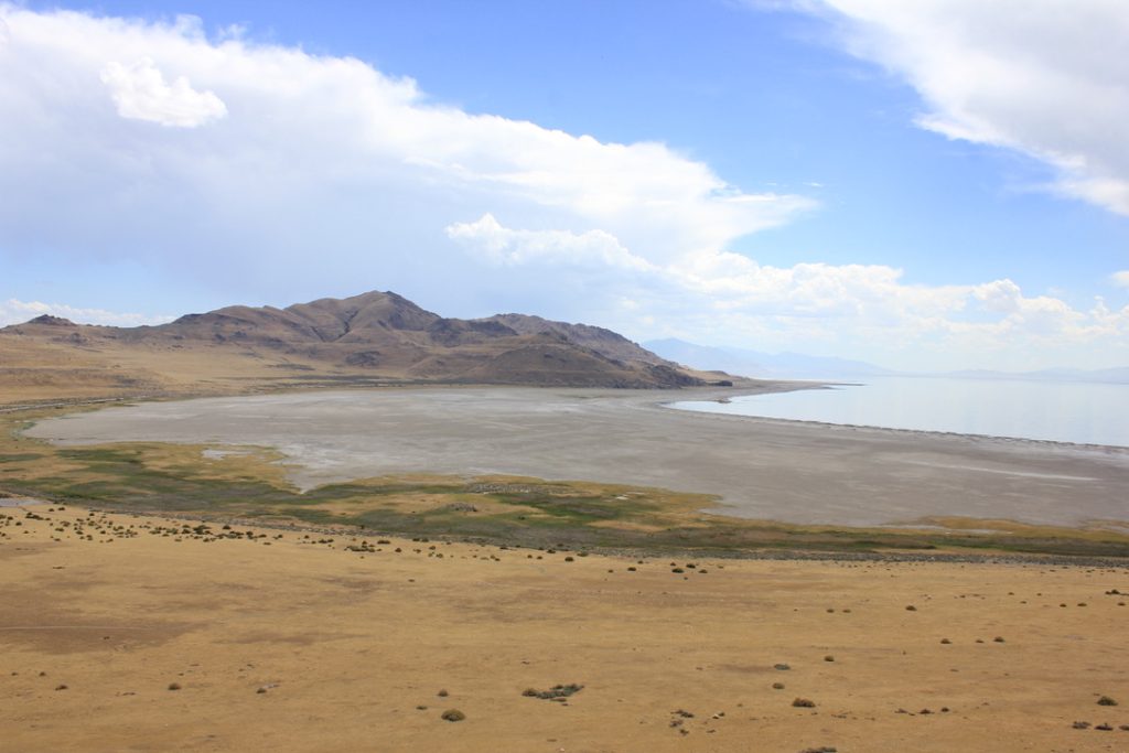
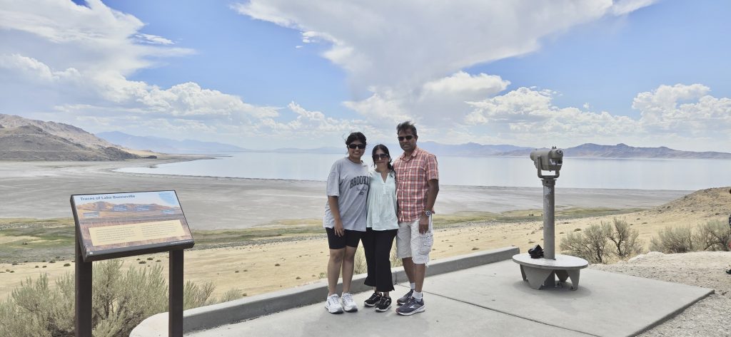
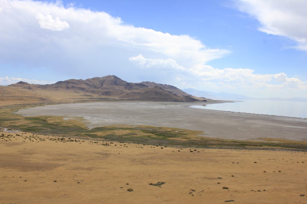
One of Utah’s most famous landmarks, the Great Salt Lake, is the largest saltwater lake in the Western Hemisphere, stretching about 75 miles long and 35 miles wide. Fed by rivers but with no outlet, minerals accumulate, creating salinity levels much higher than the ocean. For centuries, it’s been both a natural wonder and a habitat for millions of migratory birds.
We chose to experience the lake from Antelope Island State Park, the largest island on the lake. Spanning 28,000 acres, the island is renowned for its free-roaming wildlife—most famously a herd of over 500 American bison, along with pronghorn antelope, mule deer, coyotes, and countless bird species. The entry fee was $15 per vehicle, well worth the visit.
Driving across the causeway, we soon spotted bison grazing in the distance. We made our way to Buffalo Point, one of the island’s most scenic overlooks. With an easy one-mile trail, it offers sweeping views of the lake, the Wasatch Mountains, and the endless sky reflected in the shimmering waters. It was the perfect spot for family and individual photos, capturing both the beauty of the landscape and the serenity of the moment.
We spent about 90 minutes on the island, taking photos and enjoying the drive across its unique terrain before heading into the city.
Check-In at Downtown Hyatt
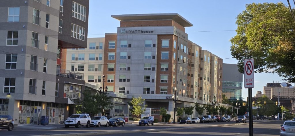
By 4:30 PM, we arrived at the Hyatt House Salt Lake City (140 S 300 W, Salt Lake City, UT 84101). The hotel was a welcome retreat: spacious rooms with kitchenettes, upscale amenities, and even free parking—an unexpected perk in a downtown location. Since it was a Sunday, we managed to get a great deal on our stay, adding to the sense of comfort and satisfaction.
Evening at Temple Square
After some refreshments with coffee and snacks, we decided to head out on foot to Temple Square, conveniently just a short walk from our hotel.
Founded in 1847 by Brigham Young and early pioneers of the Church of Jesus Christ of Latter-day Saints (Mormon Church), Temple Square spans 10 acres in the heart of downtown. It’s home to the Salt Lake Temple, Tabernacle, Assembly Hall, and several visitor centers.
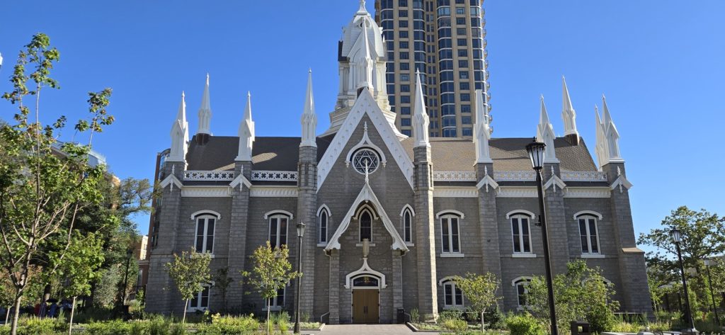
Unfortunately, the Salt Lake Temple was closed due to major reconstruction and seismic upgrades, with reopening projected between April 2027 and October 2027. Still, its towering spires and detailed Gothic-inspired architecture left a lasting impression.
Inside the Salt Lake Tabernacle, completed in 1867, we marveled at its extraordinary acoustics. The oval-shaped hall can seat over 3,000 people, and its design allows even the quietest sounds—a pin drop or whispered word—to be heard clearly across the room. Standing beneath its domed ceiling with the grand organ as backdrop was a moving experience.
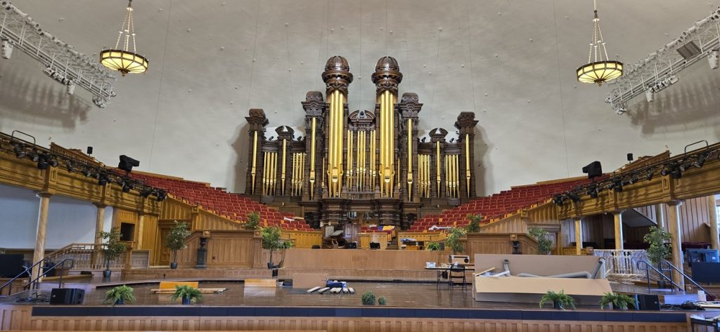
We spent a few hours exploring the grounds, admiring both the spiritual and architectural legacy. Walking back to our hotel through the streets of downtown, we were struck by how meticulously planned the city felt. With its grid layout, trams, buses, and nearby shopping malls, Salt Lake City appeared well-suited for residents and especially welcoming to the younger generation.
Summary Day 3
🥾 Day Essentials
- Water & snacks for Antelope Island
- Camera for sweeping lake and bison views
- Comfortable walking shoes for Temple Square
- Sunscreen and layers for desert-to-city transitions
📌 Road Notes
- Start: 9:30 AM, Twin Falls
- Gas: Costco Twin Falls – $3.869/gal
- Lunch: Olive Garden, Bountiful (~11:30 AM)
- Great Salt Lake: Largest saltwater lake in the Western Hemisphere (75×35 miles)
- Antelope Island State Park: 28,000 acres; bison herd, pronghorn, mule deer; $15 entry
- Buffalo Point: Easy 1-mile hike, panoramic views of lake and Wasatch Mountains
- Hotel: Hyatt Regency Salt Lake City – upscale, kitchenettes, free parking (Sunday deal)
- Temple Square: Founded 1847; 10-acre LDS spiritual hub; Temple closed until 2027; Tabernacle completed 1867, famous acoustics
💡 Our Highlights
- Affordable fuel stop at Costco Twin Falls
- Spotting bison on Antelope Island and the lake’s shimmering horizon
- The breathtaking acoustics inside the Tabernacle
- The thoughtful urban planning of Salt Lake City’s downtown
Day 3 brought us from the desert roads of Idaho into the cultural and spiritual heart of Utah. Between the natural wonder of the Great Salt Lake, the wildlife of Antelope Island, and the architectural marvels of Temple Square, it was a day that perfectly blended nature, history, and city life. Resting back at our downtown hotel, we looked forward to where Day 4 would lead us.
Day 4: Salt Lake City to Bryce Canyon — Temples, Highways & Hoodoos
After a restful night in Salt Lake City, we started Day 4 with a delicious complimentary breakfast at Hyatt House. By 10:15 AM, we had packed up, checked out, and noted the odometer—920 miles into our road trip adventure.
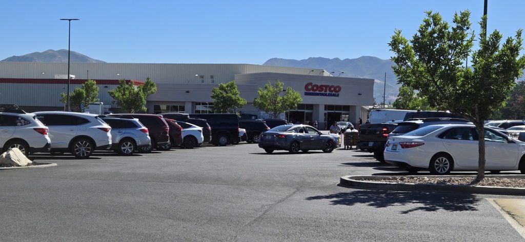
Fuel and a Landmark Costco Stop
As usual, the day began with a gas stop, and this time it was special: the Costco at 1818 S 300 W, Salt Lake City, UT—the largest Costco in the world. Filled tank with premium gas priced at $3.649 per gallon, and a quick photo marked the memory. With the car ready, we pointed ourselves south toward the canyons. We would need to drive 256 miles to reach Bryce.
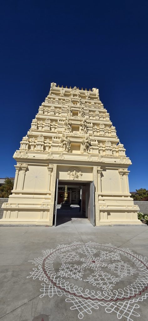
Spiritual Stops: Hindu Temples South of Salt Lake
My wife had discovered two Hindu temples just outside Salt Lake City, and both became meaningful detours.
- Sri Ganesha Hindu Temple (South Jordan, UT): A beautifully structured temple in traditional South Indian style, complete with sannidhis (shrines) for Lord Ganesha, Lord Shiva and Parvati, Lord Vishnu and Lakshmi, Andal/Bhudevi, Rama Parivar, Radha Krishna, and the Navagrahas. We had a peaceful darshan, took photos, and felt uplifted before returning to the road.
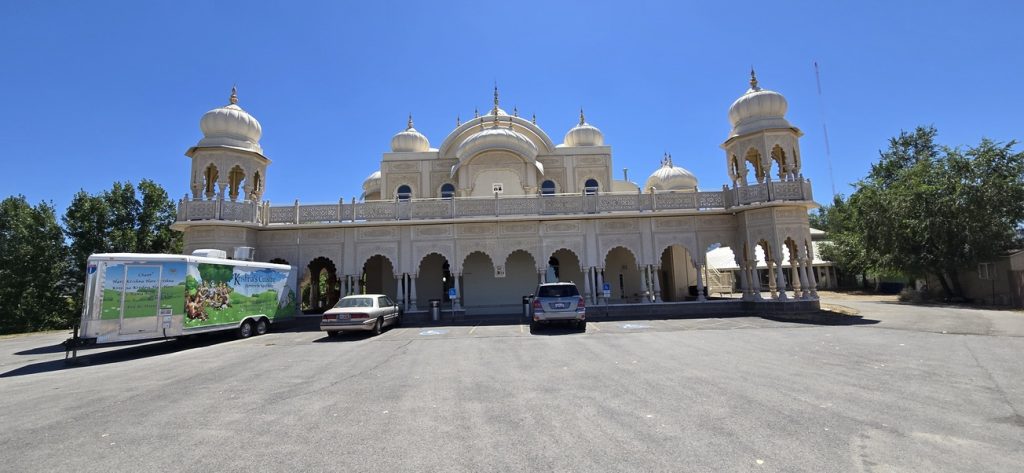
- Sri Sri Radha Krishna ISKCON Temple (Spanish Fork, UT): Rising unexpectedly against Utah’s desert backdrop, this temple resembles a Rajasthani palace and is set on a serene 15-acre site. Known for its annual Festival of Colors, it serves as a spiritual hub and cultural center. Inside, we enjoyed a blessed darshan of Radha Krishna and then indulged in a tasty vegetarian lunch buffet—just $12 per person.
Southbound on Interstate 15
Back on the road, we rejoined Interstate 15 (I-15)—a 1,433-mile north–south artery stretching from San Diego, CA to the Canadian border in Montana. It connects major cities like Las Vegas and Salt Lake City, making it one of the busiest freight corridors in the western U.S. Unsurprisingly, the road was filled with heavy truck traffic, likely en route to Los Angeles, San Diego, where I-15 ends.
An Unexpected Scenic Detour
Interestingly, Google Maps diverted us from the usual I-15 → UT-20 → US-89 → UT-12 route. Instead, we wound through US-50 East, UT-24 East, UT-62 West, UT-22 South, and finally UT-63 South. The detour may have been due to traffic or roadwork, but it rewarded us with peaceful small towns and open desert vistas—a reminder that sometimes the unplanned paths add their own charm.
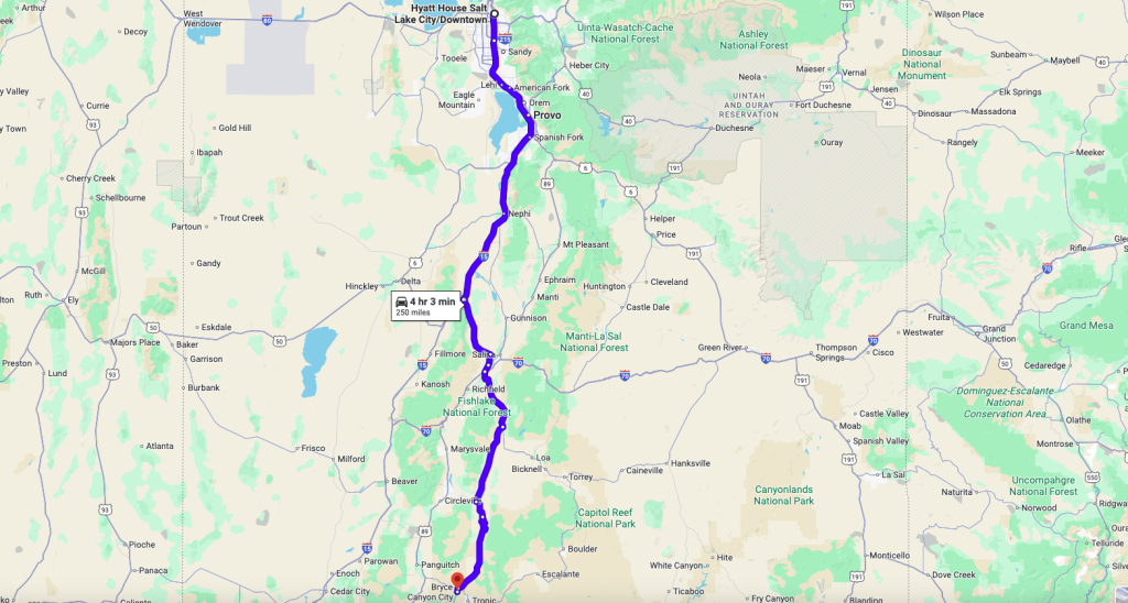
Arrival at Ruby’s Inn
By 4:30 PM, we reached our lodge for the night: the Best Western Plus Ruby’s Inn in Bryce Canyon City. Ruby’s Inn is a rustic gateway to Bryce Canyon, offering not only comfortable rooms but also a general store, dining, and even stables. It’s essentially a hub for visitors heading into the park.
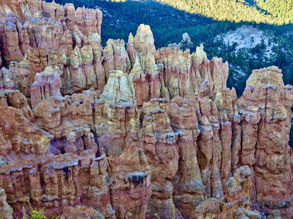
First Taste of Bryce Canyon National Park
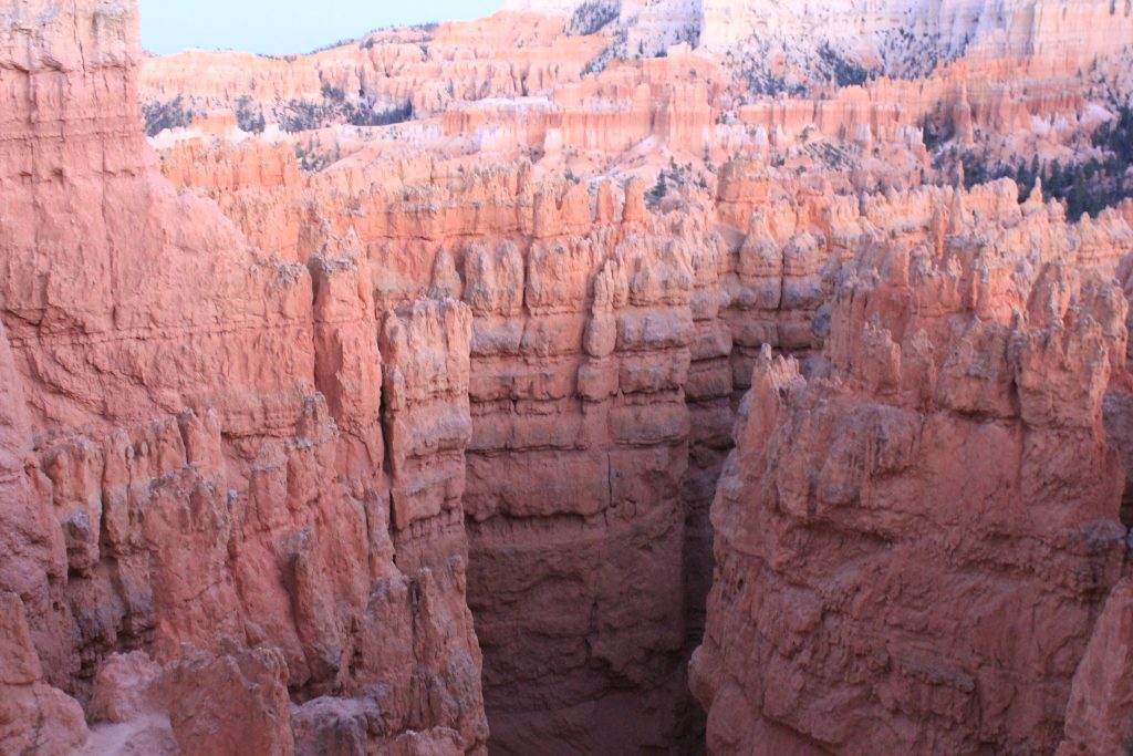
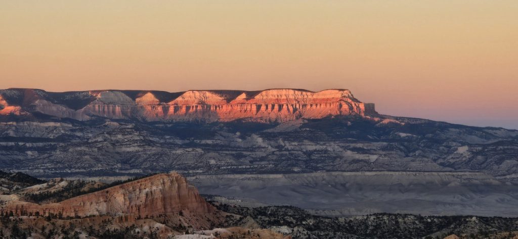
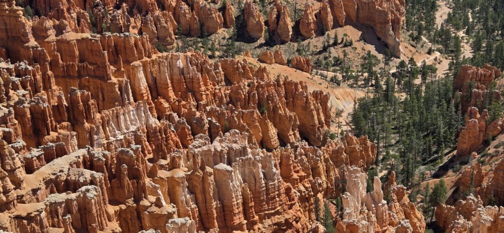
After check-in, we couldn’t resist exploring. Entry into Bryce Canyon National Park was just $35 per vehicle (valid for a week) and we drove the full length of the park road to Rainbow Point. We felt weather to be pleasant even at this time of year. We stopped at Rainbow Point first, and then on return along the way, we stopped at various scenic pullouts, each one revealing otherworldly hoodoos and amphitheaters bathed in the evening light.
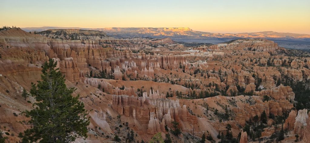
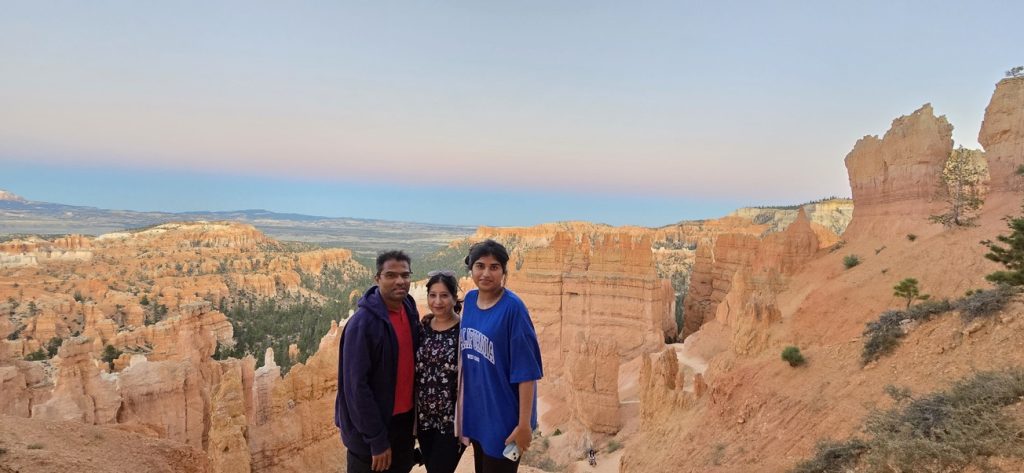
Our final stop was at Sunset Point, one of the park’s most iconic viewpoints. Overlooking the largest concentration of Bryce’s hoodoos, Sunset Point offers dramatic vistas of the Bryce Amphitheater, stretching from Inspiration Point to Bryce Point. Even though the parking lot was full, we were lucky enough to find a spot. Though there are other parking lots available nearby, which I found later, along the trail. We spent time wandering the paths, capturing photos, and simply soaking in the surreal beauty as the sun dipped below the horizon.
Closing the Day
Back at Ruby’s Inn, we ended the day with a homemade dinner packed by my wife, grateful for both the spiritual and natural experiences the day had brought.
🌟Summary Day 4
🥾 Day Essentials
- Comfortable attire for temple visits
- Vegetarian lunch at ISKCON ($12 per person)
- National Park pass or $35 entry fee for Bryce Canyon
- Camera and tripod for sunset photography
📌 Road Notes
- Start: 10:15 AM, Salt Lake City (mileage: 920)
- Gas: Costco SLC — world’s largest Costco
- Distance to Bryce Canyon – 256 miles.
- Sri Ganesha Temple, South Jordan: Traditional Hindu temple with multiple sannidhis
- ISKCON Radha Krishna Temple, Spanish Fork: Cultural landmark, Festival of Colors site, vegetarian buffet
- Interstate 15: 1,433 miles long; connects San Diego to Canadian border
- Scenic reroute via UT-28, US-89, UT-24, UT-62, UT-22, UT-63
- Best Western Plus Ruby’s Inn: Lodge with full amenities at Bryce Canyon entrance
- Bryce Canyon National Park: Entry $35, valid for a week, drove to Rainbow Point, ended at Sunset Point
💡 Our Highlights
- Spiritual serenity from visiting two beautiful temples
- Enjoying a hearty vegetarian lunch in the middle of Utah
- The surprise detour that showed us quieter corners of the state
- Watching the hoodoos glow in orange and red at Sunset Point
Day 4 combined the spiritual calm of temple visits with the majestic beauty of Bryce Canyon, reminding us that journeys are as much about the soul as the sights. With hoodoos silhouetted against the setting sun, we returned to our lodge with hearts full—ready to greet Bryce Canyon again at sunrise on Day 5.
Day 5: Sunrise at Bryce, the Scenic Drive to Zion, and First Trails
After a peaceful night at Ruby’s Inn, we started our morning with a refreshing complimentary breakfast. By 10:00 AM, bags were packed, and we checked out, eager to squeeze in a little more Bryce magic before heading south.
Morning at Bryce Canyon
We parked at Sunrise Point, one of the most popular overlooks in the park. From there, the view of the hoodoos in soft daylight was spectacular. We followed a trail for a short walk, admiring the colors and formations, while watching seasoned hikers descend deep into the canyon—a reminder of how vast and immersive Bryce really is.
On the Road Again
By noon, it was time to head toward Zion National Park. Our car’s odometer read about 1,221 miles into the trip. A quick gas stop right across from Ruby’s Inn topped us off (premium at $4.349 per gallon) before beginning the 86-mile drive south.
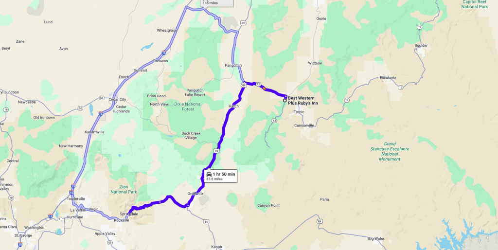
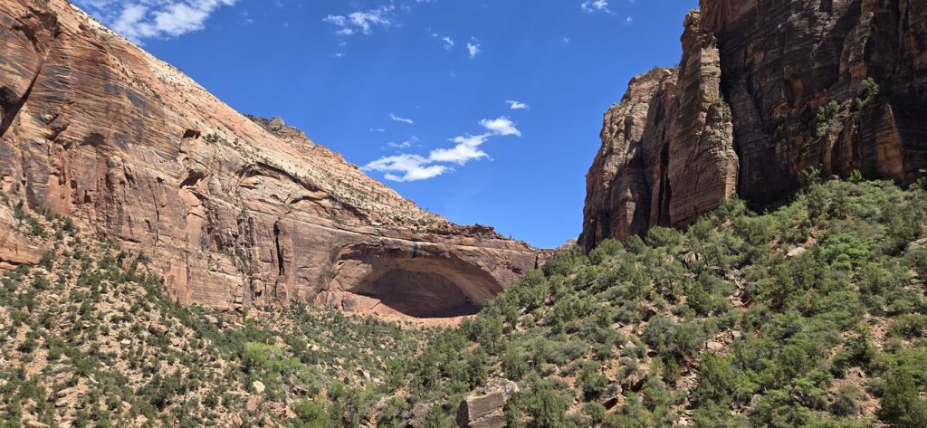
We entered Zion through the North (East) Entrance, following US-89 into the Zion–Mount Carmel Tunnel. Completed in 1930, this 1.1-mile tunnel was an engineering marvel of its time, blasted through solid sandstone to connect Zion with Bryce Canyon and the Grand Canyon. Narrow and dimly lit, it features “gallery windows” cut into the rock for ventilation and brief glimpses of the canyon outside. Emerging from the tunnel, we were greeted by towering cliffs and winding roads that demanded a photo stop—though the desert heat was a blazing 100°F.
Checking in at Bumbleberry Inn
By 3:30 PM, we rolled into Springdale and checked into the Bumbleberry Inn, a long-standing family-run hotel located less than a mile from Zion’s south entrance. Our room was cozy and practical, with a microwave and refrigerator—perfect for storing and heating up meals. The inn also has its own shuttle stop, making it incredibly convenient for exploring Zion without driving. We were going to stay for 2 nights in this hotel.
Supplies for the Stay
Before heading into the park, we stopped at Sol Foods Supermarket in Springdale. This is the town’s only full-service grocery store, offering fresh produce, packaged foods, outdoor gear, and even hardware items. It’s a lifeline for park visitors stocking up on snacks, picnic lunches, or last-minute essentials. We paired our grocery run with a homemade packed meal my wife had prepared, keeping lunch simple and satisfying.
First Look at Zion
In the evening, it was time for our first taste of Zion. We boarded the Springdale Shuttle right outside our hotel. This free service runs along Zion Park Boulevard, linking local hotels and shops to the park entrance.
At the Zion Visitor Center, we switched to the Zion Canyon Shuttle. Since private vehicles aren’t allowed on the Scenic Drive during peak season, the shuttle is the only way to access the canyon in summer. This system helps reduce traffic, protect the fragile environment, and manage the millions of visitors who pass through each year. The shuttles run every 10–15 minutes between 6:00 AM and 8:00 PM, stopping at all major attractions along the canyon floor.
Scenic Stops by Shuttle
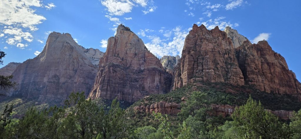
Our first stop was the Court of the Patriarchs, a trio of towering sandstone cliffs named Abraham, Isaac, and Jacob by early Mormon settlers. From the overlook, we snapped photos of the dramatic formations glowing in the late afternoon light.
We then hopped back on and got off at Zion Lodge, the only in-park lodging, surrounded by giant cottonwoods. From there, we walked the short Emerald Pools Trail—about 1 mile round trip—to the Lower Emerald Pool. The shaded path led us to a gentle waterfall and reflective pool, a refreshing pause amid the canyon heat. The trail was bustling, with many international visitors soaking in Zion’s beauty.
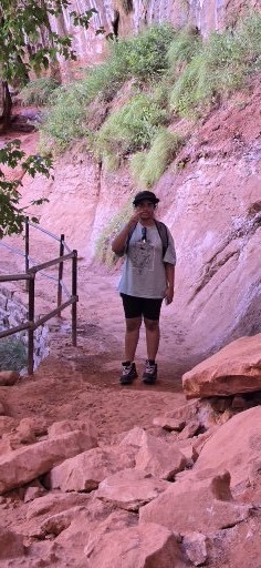
On our return, we rode the shuttle back down to the South Visitor Center, where we made a final stop to rent gear, the company Zion Outrigger, for our big hike the next day: The Narrows. Boots, neoprene socks, and hiking sticks were neatly packed for tomorrow’s adventure. It was $32.00 to rent boots, socks and hiking sticks per person.
Carrying our rentals, we hopped back on the Springdale Shuttle, the last shuttle of the day at 8pm, and rode back to our hotel. After a homemade dinner, we turned in for the night, already excited for what Day 6 would bring.
🌟 Summary Day 5
🥾 Day Essentials
- Breakfast at Ruby’s Inn set us up perfectly
- Gas top-off at Bryce City station: premium $4.349/gal
- Sunscreen, hats, and water—100°F in Zion!
- Shuttle schedules (Springdale + Zion Canyon) handy for planning
📌 Road Notes
- Start: 10 AM checkout, odometer ~1,221 miles
- Sunrise Point: panoramic views, trail access into Bryce Amphitheater
- Zion–Mount Carmel Tunnel: 1.1 miles, built 1930, connects Zion with Bryce/Grand Canyon
- Bumbleberry Inn: family-run hotel, ~1 mile from park entrance, with shuttle stop, microwave, fridge
- Sol Foods Supermarket: Springdale’s only full-service grocery + outdoor supply store
- Shuttle Systems:
- Springdale Shuttle (hotel-to-entrance)
- Zion Canyon Shuttle (inside park, 9 stops, 6 AM–8 PM, every 10–15 min)
- Court of the Patriarchs: iconic cliffs, quick overlook stop
- Emerald Pools Trail: ~1 mile, easy walk to Lower Pool waterfall
- Gear Rental: boots, socks, sticks for The Narrows at outfitters near Visitor Center
💡 Our Highlights
- Watching expert hikers descend into Bryce from Sunrise Point
- Driving through the historic tunnel into Zion’s cliffs
- The convenience of shuttles making the park accessible without stress
- Cooling off at the Lower Emerald Pool in 100°F heat
- Prepping gear for The Narrows—the big hike ahead
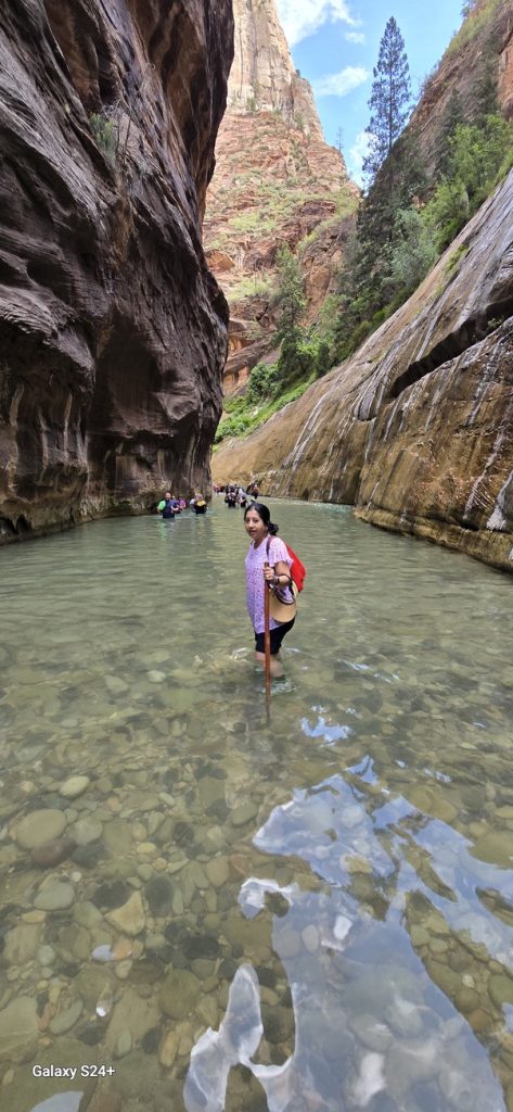
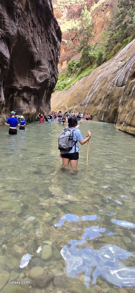
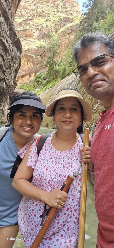
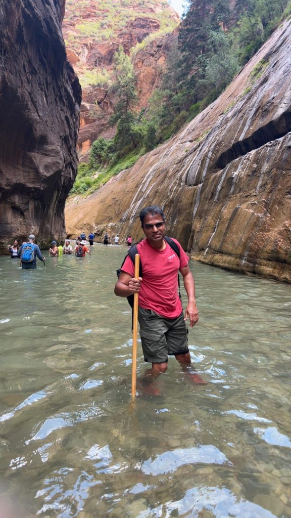
Day 6: Into the Narrows — River Trails, Shuttle Rides & Shaded Canyons
After a night’s rest in Springdale, the memory of Zion’s towering cliffs and our first glimpse of the canyon the previous afternoon still lingered with us. The shuttles, the emerald pools, and that first sense of scale had only whetted our appetite. Today was the day we would dive deeper—literally—into Zion’s heart, with The Narrows waiting to be explored. A relaxing breakfast at Porter’s Restaurant in Springdale fueled us up for the day ahead at Zion’s iconic Narrows.
We geared up and boarded the Springdale Shuttle at 10:00 AM, taking it to the Zion Visitor Center. We checked the park’s flash flood advisories on the Zion Outfitter board before diving in—safety first when hiking through canyon slot trails.
From there, we boarded the Zion Canyon Shuttle, packed with travelers from around the world—some heading for the adrenaline-inducing Angels Landing, but we were bound for a wetter sort of adventure: The Narrows.
From Temple of Sinawava to the Riverside Walk
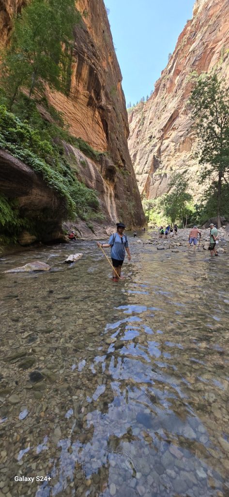
We disembarked at the shuttle’s final stop, the Temple of Sinawava, a natural amphitheater carved by the Virgin River. It’s also the gateway to the Riverside Walk, a peaceful, paved trail following the river into ever-narrowing sandstone walls—a scenic 1-mile round-trip. This is where the main Narrows hike begins.
Into the Narrows (Bottom-Up Hike)
We walked the Riverside path until it opened into the Virgin River, where the Bottom-Up Narrows hike begins. This form of the hike allows visitors to go as far as they like upstream before turning back.
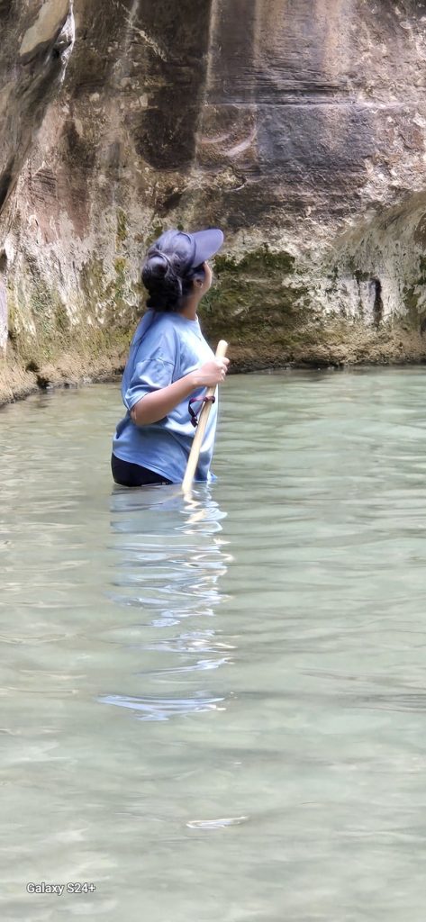
Stepping into the water—just a moment of wet feet—felt exhilarating. The narrow canyon walls soared around us, offering shade from the 100°F sun. Families, couples, and solo adventurers all navigated the gently flowing water, immersed in this unique river journey.
We continued until the water deepened to about 2–2.5 feet, just past the Lower Narrows zone. Though many kept going further, we decided that was our sweet spot and turned back, having spent approximately 80–90 minutes wading through the canyon river.
The experience was unforgettable—cool water, towering cliffs, and a sense of stepping outside of everyday life.
Back to Springdale for Lunch and Relaxed Evening
After hiking back on the Riverside Walk and returning our gear at the Visitor Center, we hopped back on the shuttle to Springdale for a late Thai lunch at Thai Sapa—a popular family-owned restaurant with warm hospitality and great food.
Full and content, we returned to our hotel for the evening. We relaxed, caught up on laundry, enjoyed a light homemade dinner, and reflected on a day that was adventurous, refreshing, and simply “one of a kind.”
Summary Day 6
Day Essentials
- Waterproof footwear or sandals—expect to get wet!
- Hydration and snacks—especially since heat and exertion combine
- Check flash flood risk at Zion Outfitter or Visitor Center before heading into Narrows
- Gear: rented boots, socks, sticks—essential for river wading
Trail & Shuttle Notes
- Trailhead: Temple of Sinawava → Riverside Walk → Bottom-Up Narrows hike (~3.6 miles round trip option)
- Angels Landing: Dramatic ridge hike with chains; permits now required due to safety and crowd control
- Riverside Walk: A family-friendly paved trail into the canyon
- The Narrows: Hiking in river between slot canyon walls; flash flood risk—water levels can rise dramatically during storms
- Shuttle schedules: Springdale to Visitor Center + Zion Canyon Scenic Drive (required in peak season) (Business Insider)
- Thai Sapa Restaurant: Local family-run spot serving Thai cuisine—convenient stop post-hike
Our Highlights
Relaxing with Thai food after a day of canyon immersion
That initial step into the cold river—a shock and delight
The play of light and shadow in the canyon—magical and meditative
Hiking with strangers, but sharing smiles in flowing water
Our time in The Narrows became more than just a hike—it was a reminder of how alive a canyon can feel when water, stone, and people meet in harmony. Wading through the Virgin River, shaded by cliffs that seemed eternal, gave us a whole new perspective on Zion. Returning to Springdale with tired feet and full hearts, we knew this day would stand apart from so many others on our trip
In the river’s flow and canyon’s hush, we felt both adventure and eternity.
Day 7: Scenic Roads from Zion to the Grand Canyon
Waking up in Springdale after our Zion adventures, we packed the van and refueled with a strong breakfast at Porter’s Restaurant before embarking toward the next colossal wonder: the Grand Canyon South Rim. The odometer read a mile-strong 1,306.4 miles and counting. It was 10:00am and distance to travel 257 miles.
Canyon Overlook: Zion’s Final Vista
Before bidding farewell to Zion, we couldn’t resist the trek to Canyon Overlook, just north of the Zion–Mount Carmel Tunnel. The trail is a manageable 1-mile round trip, featuring sandstone steps, handrails, and a lookout that frames the Towers of the Virgin, slot canyons, and possibly bighorn sheep in the distance (National Park Service). A 35–40 minute climb rewarded us with sweeping views; the descent took roughly 25 minutes. A powerful canyon finale.

Goodbye, Zion – Hello, Grand Canyon
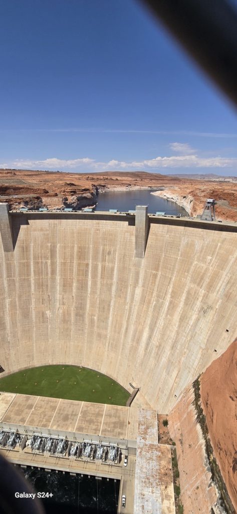
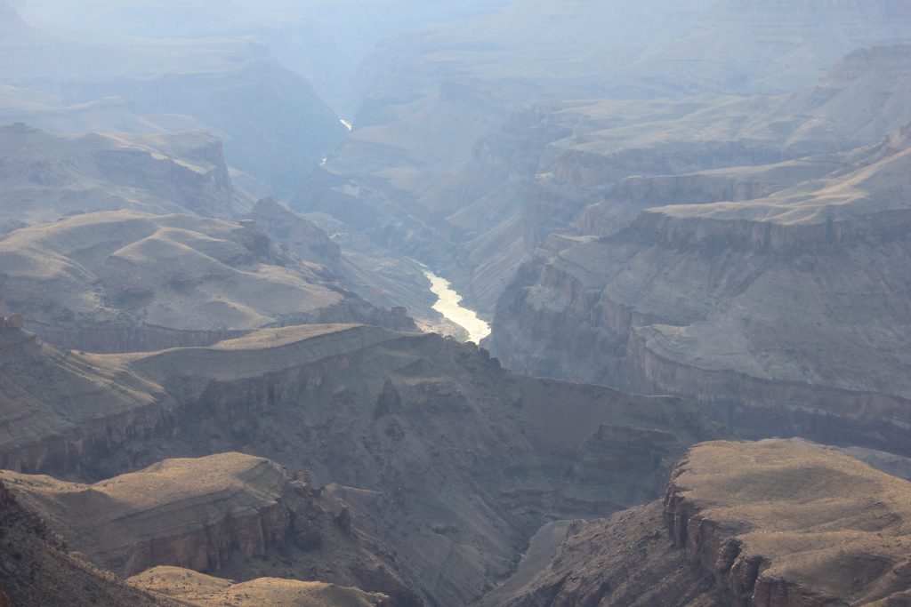
Back on the road, we crossed from Utah into Arizona—mindful of the time change. As we navigated US-89 south, We took a detour to the Glen Canyon Dam Overlook, gazing upon the imposing dam built between 1956 and 1966. Its arch-gravity structure, towering 710 feet over the Colorado River, impounds Lake Powell—one of the nation’s largest reservoirs and a vital source of hydroelectric power (Wikipedia).
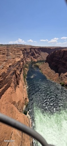
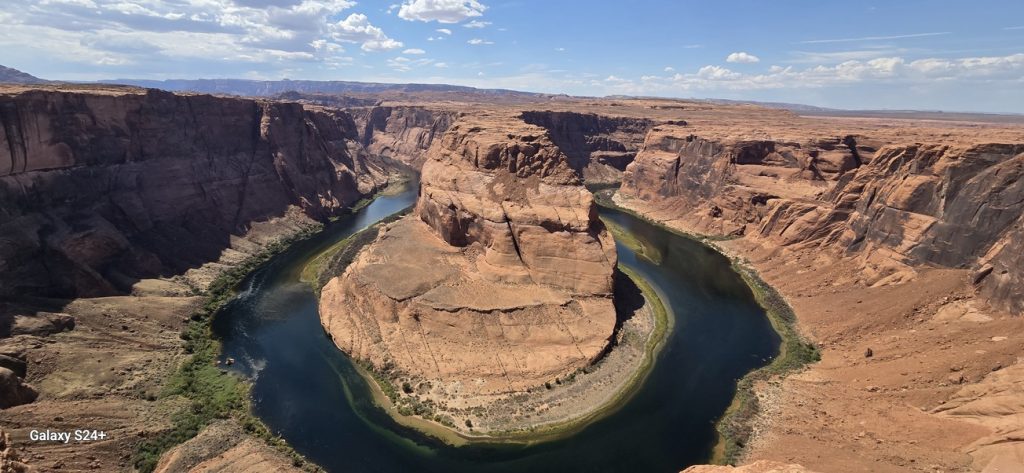
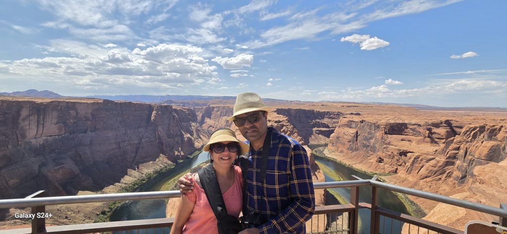
Soon after, we found ourselves in Page, AZ, where we grabbed a quick bite at Taco Bell and headed to Horseshoe Bend. At $10 per vehicle, we hiked about 0.7–1.5 miles round trip along a paved and gently graded trail to the rim of this iconic Colorado River meander—it’s unreal to see that 1,000-foot drop and mile-wide curve in person (Horseshoe Bend).
Final Stretch to the Canyon
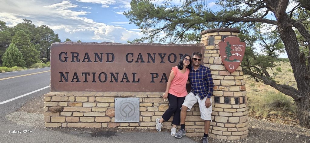
We refueled again at Cameron, AZ—premium gas was $3.539/gallon—before turning west onto AZ-64 toward the South Rim entrance of the Grand Canyon, paying the $35 vehicle fee valid for a full week of exploring.
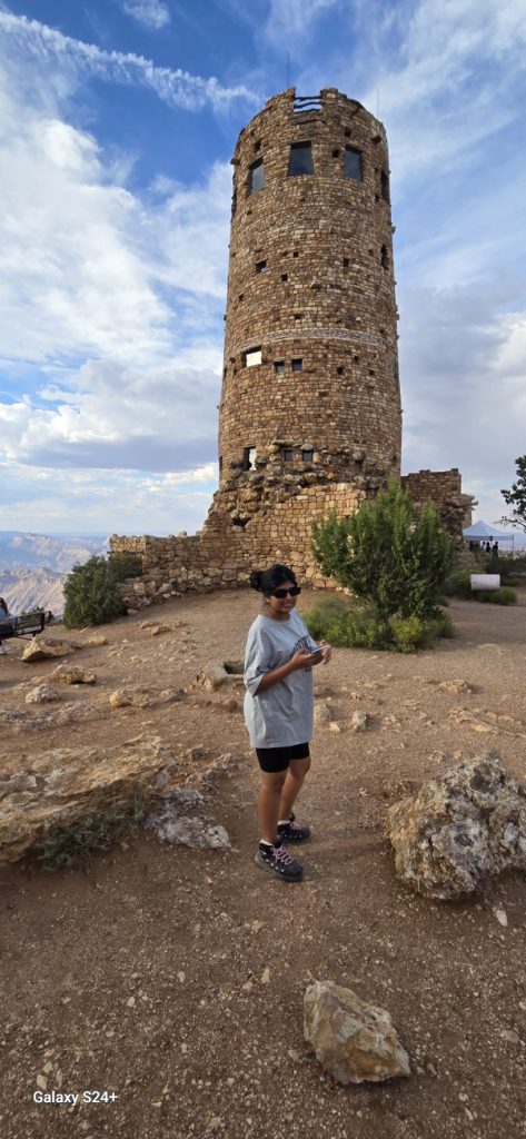
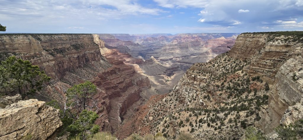
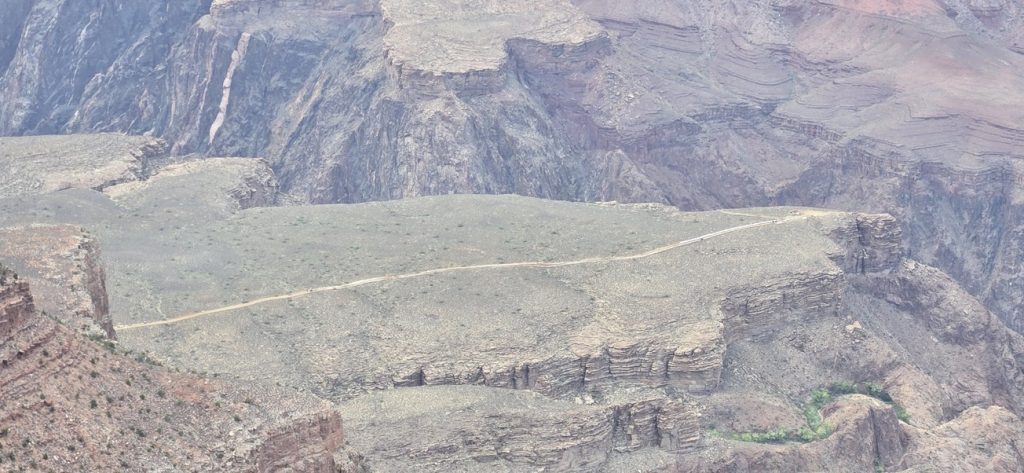
Along the scenic Desert View Drive, we made stops at key overlooks and viewpoints, absorbing the canyon’s layered complexity as it stretched to the horizon.
By 7:15 PM, we arrived at Maswik Lodge in Grand Canyon Village, checking into the “Fern” building. Nestled among ponderosa pines, this lodge is just a quarter-mile from the rim and offers cozy rooms, food court access, and even EV charging (National Park Service).
To top off the day, my daughter and I ran to the South Rim Market for groceries for our two-night stay, while my wife prepared a comforting home-style dinner—ending a long but adventure-packed day at the edge of the world.
Summary Day 7
Day Essentials
- Sunscreen and hat—desert heat can be intense
- Trail-friendly shoes for Canyon Overlook and Horseshoe Bend
- Camera for panoramic canyon shots
- Be aware of the Arizona time zone change
Road & Route Highlights
- Canyon Overlook Trail: 1-mile hike, moderate difficulty, excellent view (National Park Service)
- Glen Canyon Dam: 710-ft arch-gravity dam, forms Lake Powell, built 1956–1966 (Wikipedia)
- Horseshoe Bend: $10 parking fee; ~0.7–1.5-mile hike; rim view of Colorado River meander (Horseshoe Bend)
- Maswik Lodge: Within Grand Canyon Village; pines, food court, EV charger, steps from rim (Grand Canyon Lodges)
Our Highlights
- That final sunrise-like view from Canyon Overlook—a fitting goodbye to Zion
- The massive engineering of Glen Canyon Dam and peaceful Lake Powell vista
- The jaw-dropping rim view at Horseshoe Bend—nothing prepares you for it
- Settling into Maswik Lodge under pine trees, with the canyon waiting outside
Day 8: A Day on the Rims — Shuttles, Overlooks & Sunset Magic
After a restful night at Maswik Lodge, it was time to truly explore the Grand Canyon. Other than the Desert View Drive (where private vehicles are allowed), most of the South Rim roads inside Grand Canyon Village are accessible only by shuttle bus during the busy season. It’s an efficient, eco-friendly system that cuts traffic and protects the fragile environment.
Shuttle System at the Grand Canyon
The park runs four main shuttle lines:
- Village (Blue) Route – links lodges, Visitor Center, and Market Plaza.
- Kaibab/Rim (Orange) Route – connects Visitor Center with viewpoints like Yavapai and Yaki.
- Hermits Rest (Red) Route – scenic shuttle to overlooks west of the Village along Hermit Road.
- Tusayan Route (Purple) – seasonal line from the nearby town of Tusayan into the park.
Morning on the Hermit Road (Red Route)
After breakfast, we walked about 7–8 minutes from Maswik Lodge to the Village transfer stop and hopped on the Hermits Rest Shuttle (Red Route) at 10:00 AM. This route has some of the most spectacular overlooks on the South Rim, and we made several memorable stops:
- Powell Point: Named for Major John Wesley Powell, the explorer who led the 1869 and 1871–72 river expeditions down the Colorado, mapping the canyon. A stone memorial here honors his pioneering work.
- Hopi Point: Famous for wide panoramas and considered one of the best spots for sunrise and sunset. From here, you can also glimpse distant rock formations like Shiva Temple and Buddha Temple.
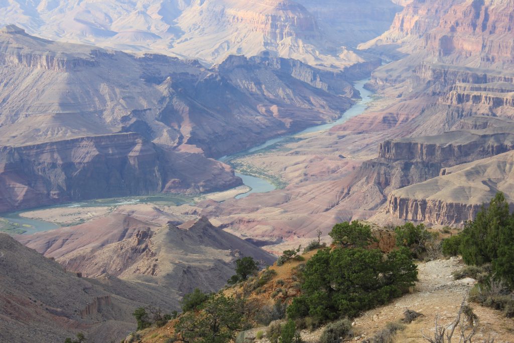
- Mohave Point, Monument Creek Vista, Pima Point: Each offered new perspectives—the Colorado River glinting far below, endless ridgelines, and deep cut canyons.
The buttes we saw in the distance—Shiva Temple and Buddha Temple—were named in the late 1800s by geologist Clarence Dutton, who felt the formations resembled ancient temples. Dutton began a tradition of naming canyon features after deities, explorers, and mythological figures. Shiva Temple rises over 7,600 feet and was once even studied as a potential wildlife refuge. Buddha Temple, with its distinctive blocky summit, mirrors the timeless stillness of its namesake.
By early afternoon, we returned to the lodge around 1:00 PM for a simple lunch and some rest.
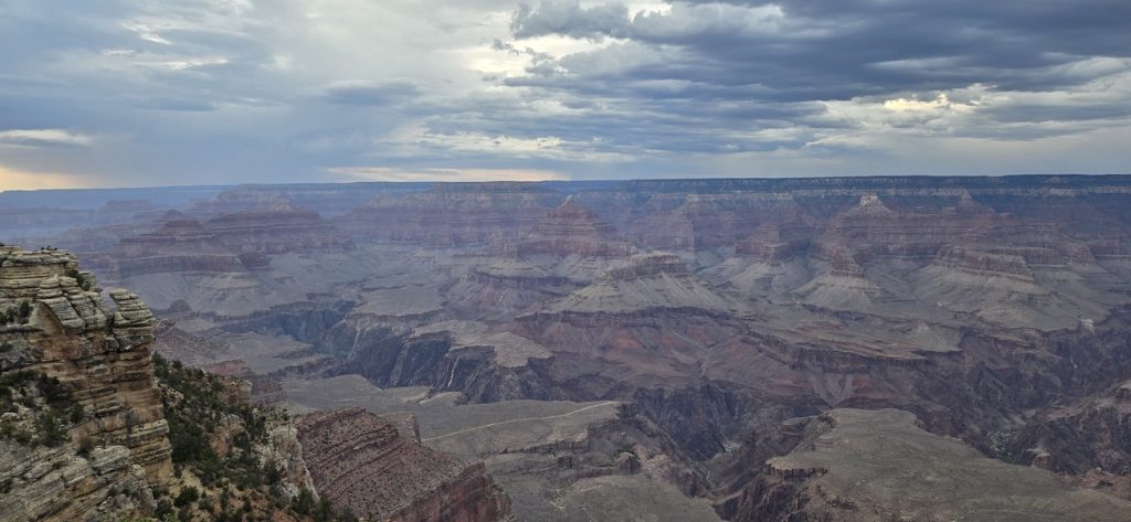
Evening on the Rim — Yavapai & Mather Points
Around 5:00 PM, we ventured back out, this time using the Village (Blue) Route to connect with the Kaibab/Rim (Orange) Route toward the Visitor Center. Our goal was to catch the evening light at two iconic overlooks:
- Yavapai Point: Located near the Yavapai Geology Museum, it offers one of the best panoramic views of the canyon and clear sightlines to the Colorado River. It’s also a great spot to understand the geology with interpretive exhibits nearby.
- Mather Point: Just a short walk from the Visitor Center, it’s one of the park’s most popular spots for sunrise and sunset. Named after Stephen Mather, the first director of the National Park Service, it’s accessible and dramatic, with railings that edge right up to sweeping canyon drops.
Although the evening was cloudy and breezy, the scenery didn’t disappoint. Tourists strolled the Rim Trail, leading to Mather Point, and the atmosphere was electric as everyone waited for the sun to dip. We stayed until sunset, soaking in the shifting light and capturing photos of the canyon cloaked in late-day hues. Hopped onto Blue Shuttle Line from Visitor Center and returned to Lodge.
Returning to Maswik Lodge, we enjoyed dinner and prepared for the next day’s leg of the journey—our drive to Las Vegas.
🌟 Summary Day 8
🥾 Day Essentials
- Comfortable walking shoes for Rim Trail strolls
- Sunscreen & hat for midday shuttle tours
- Light jacket for breezy evenings at the rim
- Shuttle schedules in hand to avoid wait times
📌 Shuttle & Overlook Notes
- Red Route (Hermits Rest): Powell Point, Hopi Point, Mohave, Monument Creek, Pima, Hermits Rest
- Orange Route (Kaibab/Rim): Access to Yavapai Point, Yaki Point
- Blue Route (Village): Lodges, Market Plaza, Visitor Center link
- Tusayan Route (Purple): From Tusayan town (seasonal)
- Powell Point: Honors John Wesley Powell’s explorations
- Shiva & Buddha Temples: Named by Clarence Dutton, resembling temples in form
- Yavapai Point: Views of Colorado River, Geology Museum nearby
- Mather Point: Iconic, accessible overlook named for Stephen Mather
💡 Our Highlights
- Honoring Powell’s pioneering spirit at Powell Point
- Spotting the mythic Shiva & Buddha Temples from Hopi Point
- Watching tourists and families gather at Mather Point for sunset
- The canyon’s shifting colors under clouds—serene, timeless, unforgettable
Day 9: Grand Canyon South Rim → Las Vegas — From Rim Shivers to Neon Lights
After a final breakfast at Maswik Lodge, we loaded the car and departed at 10:00 AM, ready for the next leg. The odometer showed 1,564 miles on our trip so far. We had 286 miles ahead on the drive to Las Vegas.
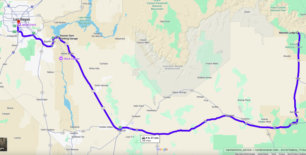
Road Views, Stops & Detours
We drove south on AZ-64, soaking in that final rim view of the Grand Canyon, then merged onto I-40 west and then on to US-93 North, crossing through stretches of desert, changing rock colors, and distant mountains that shimmered under the midday sun.
Around 12:30 PM, we stopped in Kingman, Arizona for lunch at Panda Express, and filled up with premium gas at about $4.499 per gallon.
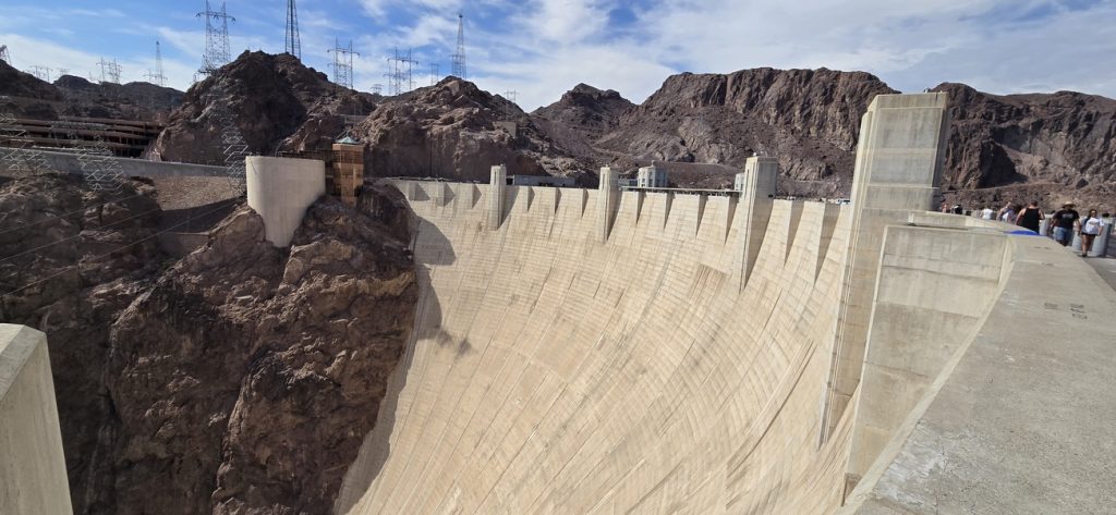
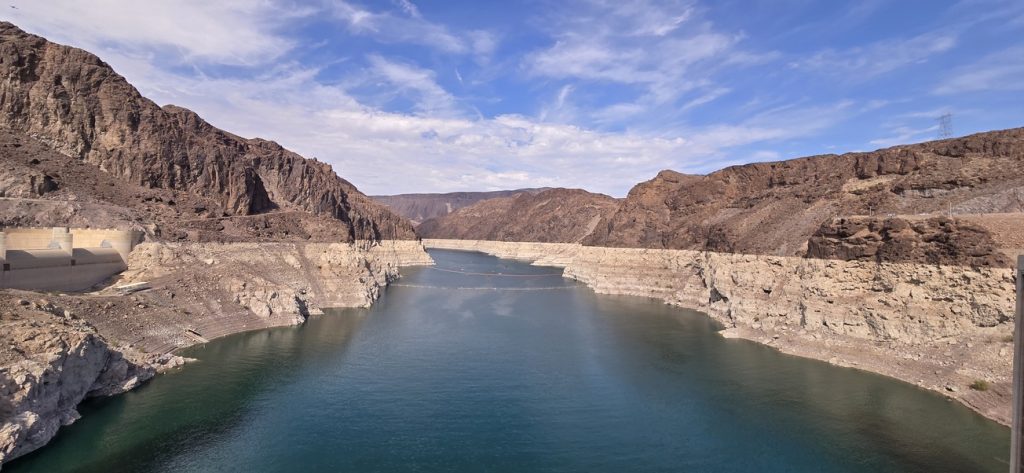
Hoover Dam Pause
By about 2:30 PM, we arrived at the Hoover Dam Visitor Center. The dam sits on the border between Nevada and Arizona, spans the Colorado River, and is perched above Lake Mead, one of the largest man-made reservoirs in the U.S. It was built during the New Deal era (construction 1931-1936) to offer flood control, hydroelectric power, and water storage.
We didn’t take the full dam tour (which can take 2–3 hours), but the Visitor Center gave wonderful views, exhibits, and photo opportunities. Parking was free; the visitor center fee per person was roughly $15.

Arrival & Vegas Night
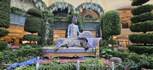
After Hoover Dam, the drive to Las Vegas took about 30 minutes. We pulled in at Treasure Island Hotel & Casino (“TI”) around 4:50 PM. Located on the Strip, TI is styled with a resort-casino blend, lots of restaurants, a big casino floor, a spa, and two pool bars among its amenities. Guest parking was free, which made it easier after the long drive.
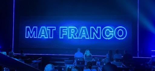
That evening, we attended the Mat Franco: Magic Reinvented Nightly show at The LINQ. It’s his first major Las Vegas residency since winning America’s Got Talent, known for a mix of illusion, crowd interaction, and sleight-of-hand. After the show, we had dinner at Canonita, a Mexican “city soul food” style restaurant in The Venetian—colorful decor, flavorful food, and lively atmosphere.
Later, we walked around The Venetian and Wynn, soaking in the lights, the gondolas, the bustling crowd, and took lots of photos—especially since it was our teenage daughter’s first time in Las Vegas.
We also noticed that The Mirage has closed its doors—an end of an era on the Las Vegas Strip. But the site isn’t staying quiet for long. It’s being completely redeveloped into Hard Rock Las Vegas, featuring a striking guitar-shaped hotel tower, expanded casino space, and over 3,700 rooms. The project is already underway and is expected to open in late 2027, marking a new chapter for one of the Strip’s most famous addresses.
We ended the night back at TI to rest.
📝 Summary Day 9
Day Essentials
- Sunscreen & hat—desert heat still strong
- Water & snacks for longer stretches outside towns
- Camera or phone with good battery for Hoover Dam & Vegas lights
- Ear-plugs? (Vegas gets lively at night)
Notes & Tips
- Hoover Dam Visitor Center: free parking; exhibits; fee ~$15/person for visitor center entrance
- Treasure Island (TI): Pirate/theme history, 2,885 rooms, several bars/restaurants, spa & casino on the Strip
- Mat Franco Show: “Magic Reinvented Nightly” at The LINQ—interactive magic, illusion focus
What’s Replacing The Mirage?
- Closed: July 2024
- Coming Soon: Hard Rock Las Vegas
- Signature Feature: Guitar-shaped tower
- Rooms: ~3,700 (675 in the guitar tower)
- Casino: ~174,000 sq. ft.
- Opening: Q4 2027
Reflective Closing
Day 9 felt like a bridge—leaving the sublime majesty of the Grand Canyon and driving into the electric heartbeat of Las Vegas. Hoover Dam’s gravity, the flare of Strip lights, magic in the air—it was a reminder of contrast, of places where nature and spectacle meet.
“From canyon’s edge to neon blaze, we crossed worlds in a single day.”
Day 10: Another Day in Las Vegas — Wander, Show & Neon Lights
We took it easy today—no rush, no long drives. After breakfast, we hung back and let the energy of Las Vegas come to us.
Midday Stroll & Sights
Around 11:30 AM, feeling refreshed, we left Treasure Island and walked over to The Forum Shops at Caesars Palace. We explored Caesars Forum, admired its interior design, and then stopped for lunch at Buddy V’s Pizzeria by Buddy Valastro—located in the Caesars Palace Forum Food Hall. It delivers bold flavors of New York-style pizza, homemade mozzarella, and Italian-Americana classics.
After lunch, we caught the Fall of Atlantis Show inside the Forum Shops. This animatronic spectacle features life-size statues, fire, water, and special effects telling the mythical story of Atlantis. It runs every hour from noon to 8:00 pm, Thursday through Monday.
Botanical Escapes & Tram Rides
Next, we made our way to Bellagio and visited the Conservatory & Botanical Gardens—a lush 14,000-square-foot display that changes with the seasons. It was a peaceful, fragrant retreat amid the Strip’s buzz.
To move between hotels and stops without excessive walking, we used the Aria Express Tram, which connects Park MGM, Bellagio, and other properties via elevated tracks. It’s free and saves steps.
We wandered past the themed resorts—New York New York, Luxor, Mandalay Bay—snapping photos, enjoying neon and architecture.
Evening Magic & Dining
Around 4 PM, we returned to Treasure Island to rest up for the night. Later, dinner was at True Food Kitchen in Caesars Palace—bright, fresh, wellness-oriented fare that was a welcome contrast to the heavy indulgences of Vegas. (Details of ambience and menu: clean, modern décor, lots of healthy options and creative twists.)
Then we walked along Las Vegas Boulevard—absorbed by the neon, the energy, the moving crowds. We visited Bellagio again to see the Fountains show—every 15 minutes after 7 PM in summer—and soaked up the shimmering spectacle.
Back at the hotel, we rested and prepared for our next drive toward Bakersfield, CA.
Summary Day 10
Day Essentials
- Comfortable shoes for walking the Strip
- Water & sunscreen
- Camera for neon lights and fountain shows
- Small carry-on for sunglasses, hat—Vegas sun is strong
Sights & Features
| Spot | Details |
|---|---|
| Buddy V’s Pizzeria | New York-style pizza, Buddy “Cake Boss” flavor, part of Caesars Palace food hall. |
| Fall of Atlantis Show | Free show with animatronics in Forum Shops; runs hourly from noon-8 pm, Thurs-Mon. |
| Bellagio Conservatory & Botanical Gardens | 14,000 sq ft indoor gardens; seasonal displays; peaceful refuge amidst the Strip. |
| Aria Express Tram | Elevated people-mover connecting Park MGM, Bellagio, and CityCenter; free and efficient. |
Vegas had a rhythm today built on contrasts—bursting energy and quiet gardens, neon lights and serene fountains. Walking its Strip, seeing Atlantis rise and water dance, we felt both dazzled and grounded, grateful for days that let us breathe between the lights.
“Today we walked through light and shade, finding calm in techno shimmer and bloom.”
Day 11: En Route to Bakersfield — Storms, Roads, & a Taste of Home
We weren’t in a rush this morning since check-out was set for 12:00 noon. After a relaxed start, we grabbed our morning coffee at Starbucks and had a hearty breakfast around 11:00 AM at The Coffee Shop, inside Treasure Island.
Bags packed, we hit the road around noon toward Bakersfield, CA, a journey of about 283 miles. At this point, the van had rolled roughly 1,864 total miles.
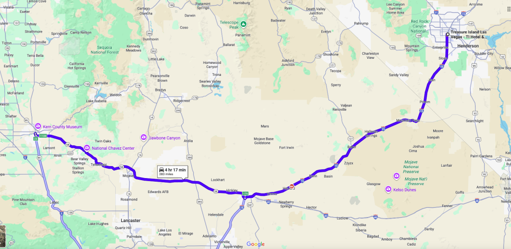
Mountain Passes & Desert Storms
We drove south on I-15, winding through the Mojave and desert foothills. As we approached Barstow and onward, the terrain shifted: increasingly open desert, scrub brush, and scattered signs of human settlement. The light changed, too—the sun intense, mirages dancing on distant horizons.
We stopped in Baker, CA to fill up at a premium gas price of $5.99 per gallon—a sharp contrast to the lower prices in many of the smaller towns. Next up was a coffee stop in Barstow, a quintessential desert town with diners, motels, and gas stations stretching off the highway. As we turned onto CA-58 West, the skies darkened: wind gusts, dust, and thunderheads built overhead. Rain slammed the windshield for stretches; visibility dropped, and for 30–40 seconds at a time, we could barely see ahead. It was both terrifying and exhilarating—the kind of road-trip moment you remember for years.
Once past the worst of the storm, the road eased. CA-58 took us through the Mojave Desert’s rugged beauty: distant mountain ranges, heat-hazed plains, and occasional mirages shimmering on the asphalt. Near Kramer Junction, traffic slowed due to road work; we were stuck for about 30-40 minutes, crawling through a stretch of repairs. But after that, the views opened up.
Arrival & Dinner in Bakersfield
We pulled into Bakersfield, CA, around 6:10 PM, checking in at the Hampton Inn & Suites Bakersfield Central, located at 1401 Easton Drive, Bakersfield, CA 93309. The hotel features free parking, a hot breakfast, outdoor pool, fitness center, and complimentary WiFi.
Feeling hungry and nostalgic, we ventured to Indian Village, a well-known Punjabi/Indian restaurant in Bakersfield. The Tawa Roti and Bhindi Bhaji transported me back home—spiced just right, full of flavor. After chatting with the staff, we learned there are about 7-8 Gurdwaras in Bakersfield, and the Sikh community there is large, active, and deeply integrated. It felt like finding a small piece of home far from it.
Full and content, we headed back to the hotel for rest, ready for Day 12.
Summary Day 11
Day Essentials
- Water, sunglasses, hat—desert sun is intense
- Extra layers for unexpected downpours or dust storms
- Snacks—gas station meals often limited in scope
- Camera or phone for storm moments—they often make the best photos
Road & Route Notes
| Segment | Notable Features |
|---|---|
| I-15 through desert passes | Mojave terrain, open vistas, sensitive to weather |
| CA-58 West | Route crosses desert and mountains; major connector; also known for scenic stretches and variable weather. |
| Baker, Barstow | Classic desert towns—gas stations, diners, brief reprieves off the interstate |
| Hampton Inn Bakersfield Central | Address: 1401 Easton Drive, Bakersfield, CA 93309; amenities include free breakfast, pool, free parking. |
Food & Community Highlights
- Indian Village Restaurant: Punjabi flavors, homestyle cooking, strong community vibe.
- Sikh/Hindu Gurdwaras: Bakersfield hosts several Sikh places of worship, deeply rooted in the local community
Day 11 reminded us that road trips aren’t just about destinations—they’re about the journeys in between. From sudden desert storms to long construction delays, the drive tested our patience and rewarded us with unexpected moments of awe. Ending the day with homestyle Indian food in Bakersfield, we felt the comfort of community thousands of miles from home.
“In the desert’s storm and the kitchen’s warmth, we found both adventure and belonging.”
Day 12: Heading Back to the Bay — Friends, Temples & Family
We awoke well rested, enjoyed a complimentary breakfast at the hotel, then checked out around 10:10 AM, loaded up the van, and hit the road for San Mateo. By then our trip mileage was 2,136 miles. The drive to San Mateo was 298 miles.
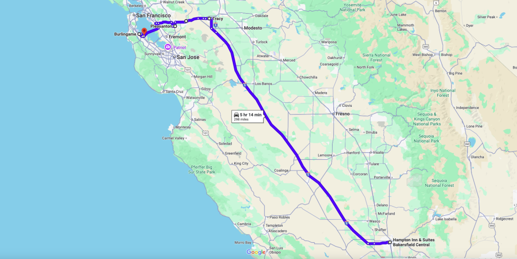
The Drive & Stops Along the Way
- First stretch was on Interstate 5, heading north through California’s Central Valley. It’s mostly flat, agricultural terrain—fields, warehouses, occasional small towns. It’s the backbone of travel in this region.
- We stopped in Tracy, CA around 2:05 PM to visit a friend I’ve known for 38 years. Lunch was at his place, lovingly prepared by his wife. It was one of those soulful pauses on a long journey.
- After lunch, we made our way to the Livermore Shiva Vishnu Temple. We arrived around 4:40 PM, in time for the Ganesh Chaturthi celebrations, and stayed until about 5:30 PM. The temple is part of the Hindu Community & Cultural Center in Livermore.
- Next, we visited family friends in Pleasanton, arriving around 5:45 PM and stayed until 7:15 PM, sipping Kumbakonam filter coffee—simple, warm, comforting.
- Dinner was in Burlingame, where we met our daughter (she’s doing a summer internship there). My friend’s wife had packed us dinner, which felt like home across all these miles.
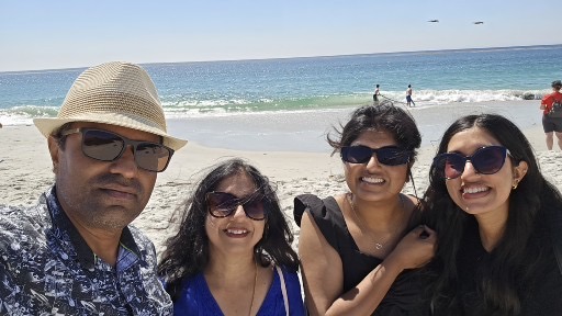
- Finally, around 9:20 PM, we arrived at Residence Inn by Marriott San Francisco/San Mateo. The location is convenient and close to workplace where our daugher is doing her internship, rooms are spacious, it has full kitchen access, and it’s calm enough after a day of travel.
Summary Day 12
Day Essentials
- Snacks and refillable water for the long drive
- Timing plans for temple visits (especially during Ganesh Chaturthi)
- Comfortable clothing for both travel and temple etiquette
Route & Place-Details
| Place | Notes |
|---|---|
| I-5 (CA) | Major north–south route through the Central Valley. Mostly flat farms, long stretches of road with occasional traffic or slowdowns near major exits. |
| Livermore Shiva Vishnu Temple | Address: 1232 Arrowhead Ave, Livermore, CA 94551. Hours: often open 9 AM–12 PM & 6–8 PM (weekday timings vary); open longer on weekends/events. |
| Residence Inn San Mateo | Good hotel, reliable chain, amenities for relaxing after travel, close to family/friends in Bay Area. |
Today was a reminder that the heart of travel isn’t always the landmarks—it’s the people, the shared meals, and moments of home found far from home. Seeing my daughter, catching up with old friends, celebrating together, it made all the miles feel worthwhile.
“After miles of road, it was faces and laughter that truly brought us back home.”
Day 13: Friends, Family & Ganesh Puja in Hayward
After days of packed sightseeing and long drives, Day 13 was intentionally slow. We hadn’t planned any sightseeing—just time to recharge and reconnect. The morning passed quietly with complementary breakfast at the hotel, a bit of laundry, and a light lunch. It was a chance to breathe, reflect on the journey so far, and prepare for the evening ahead.
Crossing the San Mateo–Hayward Bridge
Around 4:30 PM, we picked up our elder daughter from her workplace and set off to meet an old friend in Hayward—someone I’ve known for 32 years. The route took us across the San Mateo–Hayward Bridge, a long stretch of roadway gliding over the bay. We stopped at Costco Gas Station in Hayword to fill gas. Price of premium gas $4.499 per gallon, price still cheaper than Seattle Area.
The bridge itself is iconic: the original opened in 1929, and the current structure was completed in 1967. At just over 7 miles (11 km), it’s the longest bridge in the San Francisco Bay Area, linking the Peninsula with the East Bay. Toll is collected westbound only (from Hayward to San Mateo), and we were driving from San Mateo towards Hayward, so toll wasn’t collected. As we crossed, the late afternoon sun shimmered off the bay waters, adding to the anticipation of meeting an old friend.
Ganesh Puja & Reunion
Our friend’s home welcomed us warmly, and we were fortunate to participate in a Ganesh Puja. Ganesh Chaturthi is an 11-day festival, and this evening marked the second day of celebrations. The fragrance of incense, the sound of prayers, and the Carnatic Devotional Song, brought a festive energy that made us feel instantly at home.
While the men chatted about memories and the past days of travel, the ladies stepped out for a neighborhood walk, enjoying the cool evening air. Back inside, laughter and conversations flowed easily, bridging decades of friendship. Dinner was a spread of home-cooked dishes lovingly prepared by our friend’s wife—a meal made more special by the warmth of shared stories.
Return via the Bay
After dinner, we said our goodbyes and left around 8:45 PM, driving back toward Burlingame to drop off our daughter at her apartment. Crossing the San Mateo Bridge once more, we paid the $8 toll and admired the glittering lights reflecting on the dark waters below. Soon after, we returned to our hotel in San Mateo, hearts full from the reunion, ready to rest.
Day 14: Workplace Tour & South Indian Comfort Food
We began the day feeling well rested and fueled up with a complimentary breakfast at the hotel. By mid-morning, it was time for something we were especially looking forward to—touring our daughter’s workplace in San Mateo.
Workplace Tour & Lunch
She proudly guided us through the different office spaces, giving us a glimpse into her daily environment. Open work areas, meeting rooms, and a buzzing cafeteria—it was inspiring to see where she spends her days. Around 1:00 PM, we joined her for lunch in the company cafeteria. One of the perks of working in the Bay Area, we learned, is that many tech companies provide breakfast, lunch, and even dinner to employees—a perk both practical and social.
Afternoon Rest
After the tour and a hearty meal, we returned to the hotel. The trip’s pace was starting to catch up with us, so a quiet afternoon rest was exactly what we needed.
Evening Drive to San Jose
For dinner, we had planned a special outing: Mylapore South Indian Vegetarian Restaurant in San Jose. We left the hotel around 4:45 PM, picked up our daughter at her workplace, and set off. As expected, US-101 South was clogged with peak rush-hour traffic, compounded by an accident that slowed things further.
Luckily, my elder daughter had made a reservation through the Yelp app, which turned out to be a smart move—the restaurant is well-known and fills up quickly in the evenings.
Dinner at Mylapore
We arrived around 6:45 PM and stepped into a lively, aromatic space. The menu was a treat for South Indian food lovers: crisp dosas, soft idlis, flavorful curries, and to finish it all, a perfectly brewed Kumbakonam Filter Coffee. The taste was authentic, rich, and comforting—just what we had hoped for.
Wrapping Up the Day
After dinner, we stopped at Target and Trader Joe’s nearby for some quick shopping before heading back. We dropped our daughter off at her Burlingame apartment around 10:00 PM and returned to our hotel, ready to wind down after a day filled with both pride and comfort.
Day 15: Carmel-by-the-Sea — Storybook Streets & South Indian Flavors
We began the morning refreshed after a good night’s rest and a simple hotel breakfast. By 10:10 AM, bags packed and excitement building, we picked up our daughter from her apartment and set off toward Carmel-by-the-Sea. It’s about 100 miles south of San Mateo. The route—US-101 South, CA-85, CA-17, and finally CA-1 South along the Pacific Coast Highway—was an experience in itself. Rolling through forested hills before opening up to sweeping views of the Pacific, the drive felt like a ribbon of road strung between mountains and sea.
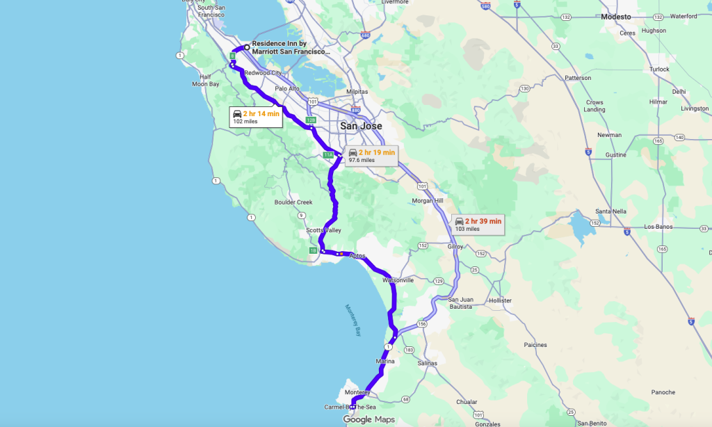
We arrived in Carmel around 12:40 PM, finding a spot in a free city lot on Torres Street – 4 Torres St, Carmel-By-The-Sea, CA 93921. The town instantly charmed us—its European-style streets lined with cozy cottages, boutique shops, and flower-framed galleries felt more like a storybook village than a California beach town. By then, we were ready for lunch, so we headed to Nora’s Carmel Comfort Cuisine, a warm, family-run spot on San Carlos Street. Known for its home-style meals, fresh ingredients, and inviting atmosphere, Nora’s lived up to its name. The food was hearty, the service exceptional, and it gave us just the pause we needed before exploring more.
From there, we wandered through the quaint streets toward Carmel Beach. This beach also has a parking lot, but it gets filled quickly. The afternoon sun lit up the soft sands and clear waters, and the crash of Pacific waves against the bluffs felt like nature’s own soundtrack. We kicked off our shoes, walked barefoot along the shore, snapped photos, and let the salty breeze wash over us. A few hours passed quickly in this little slice of coastal heaven.
On the walk back, weaving again through Carmel’s picture-perfect streets, we stopped for gelato at Gelato by the Sea—a cool, refreshing treat after hours in the sun. By late afternoon, it was time to turn back. Around 5:00 PM, we started the return drive, this time routed by Google Maps along CA-156 North and US-101 North, toward Fremont.
In Fremont, we stopped at Costco to fill up on gas (premium at $4.559 per gallon) before heading to a family friend’s home. They welcomed us warmly, along with their energetic eight-year-old twins. The evening was filled with laughter, stories, and a dinner of homemade masala dosa prepared by our friend’s wife—comfort food that hit every nostalgic note. After photos and goodbyes, we dropped our daughter at her apartment and reached our hotel around 11:00 PM, ready to sink into bed after a day that balanced beauty, family, and the flavors of home.
Day 15 reminded us that travel is not just about places—it’s about the harmony of landscapes, friendships, and familiar tastes. From Carmel’s fairytale charm to a dinner table in Fremont filled with masala dosa and laughter, the day bridged oceans and cultures in a way only journeys can.
From storybook streets to spice-laden plates, the day blended wonder with the warmth of home.
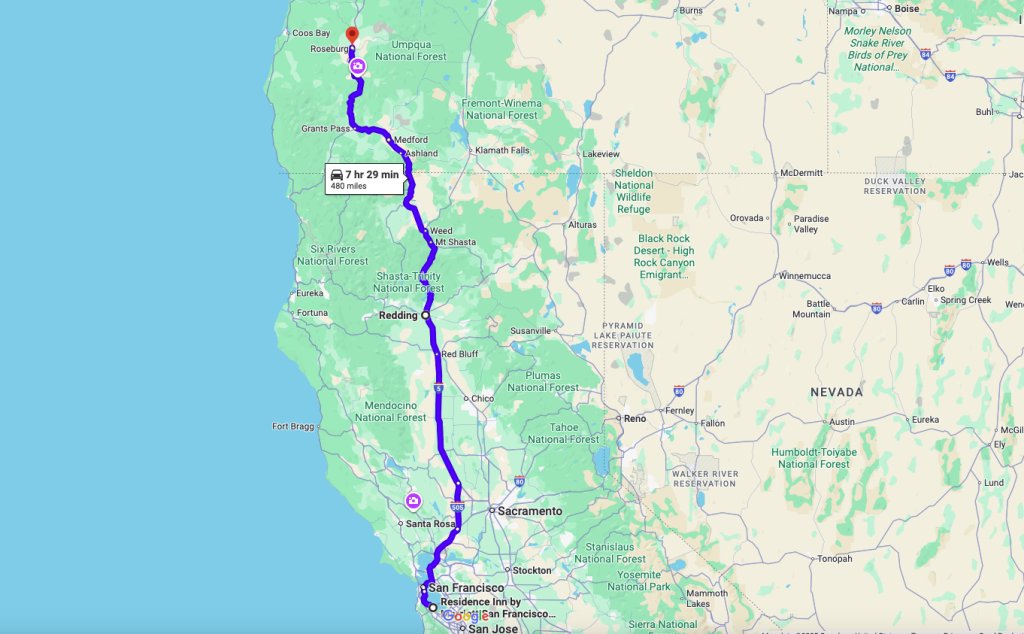
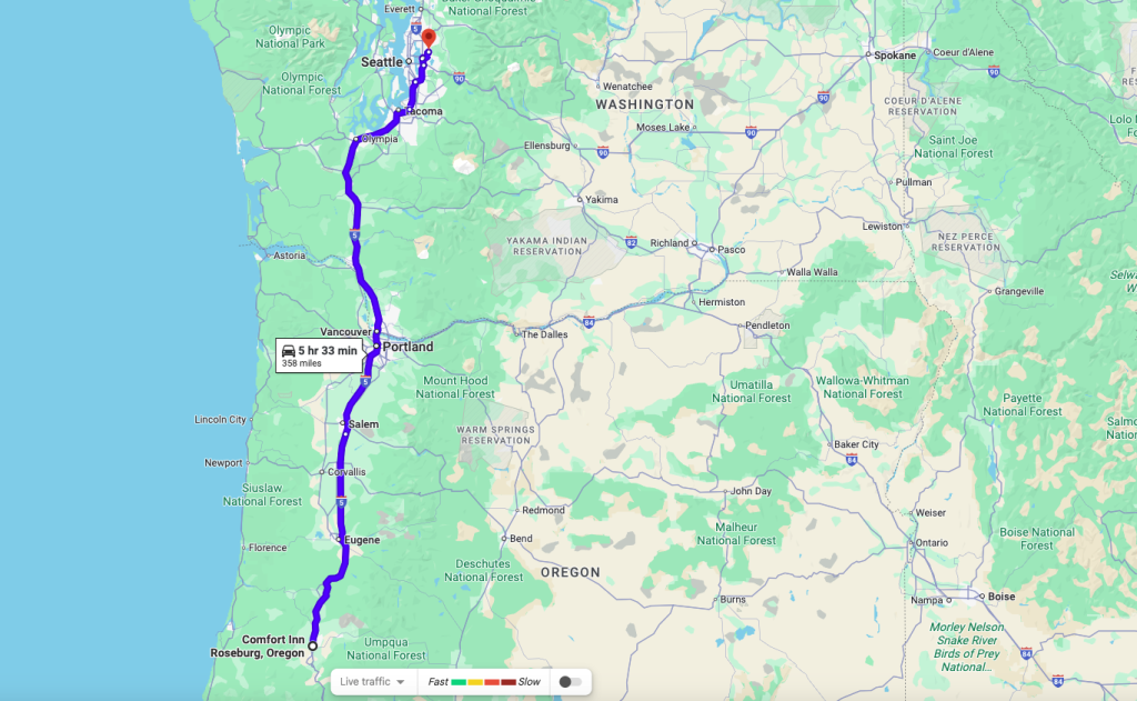
Day 16: Heading Back North — From Bay Area to Roseburg, OR – 480 miles
The morning began with a sense of transition—it was time to start the long journey home. After a simple complimentary breakfast and an 11:00 AM checkout, we packed our bags, loaded the van (now showing 2,784 miles on the odometer), and pointed north.
Leaving San Mateo meant threading through the Bay Area’s tangle of highways: I-80 East past neon billboards in San Francisco—many loudly advertising AI start-ups, a perfect reflection of the Bay Area’s current tech fever—before merging onto I-505 North. This quieter stretch bypassed Sacramento’s bustle, cutting through farmland and vineyards, before we joined I-5 North. Despite the relatively short distance, Bay Area traffic kept us crawling; it took nearly two hours before we fully settled into the freeway rhythm.
Through the Central Valley to Redding
The Central Valley drive offered flat fields, orchards, and open skies, but it was mostly utilitarian—long stretches of farmland feeding California. By 3:10 PM, we pulled into Redding, topping off the tank at Costco (premium gas at $4.159) and grabbing a quick lunch at Chipotle. When we left Redding, it was 4:10pm. With nearly 300 miles already behind us, we pressed on into northern California, where the road began to rise and the scenery shifted.
Shasta Lake & Mount Shasta
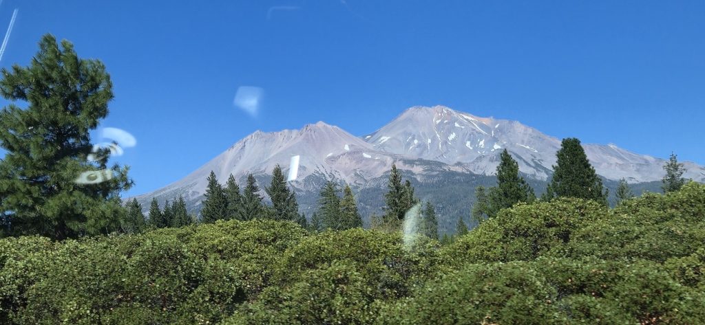
Soon we were skirting Shasta Lake, Northern California’s largest reservoir. The lake, created by Shasta Dam on the Sacramento River, is a hub for boating, fishing, and summer recreation. Even from the freeway, its blue-green waters glittered in the afternoon light, dotted with houseboats and framed by pine forests. It felt like a hidden oasis in the mountains.
And then, towering on the horizon, came Mount Shasta. At 14,179 feet, it dominates the landscape, one of the tallest peaks in the Cascade Range. A dormant stratovolcano, Shasta is steeped in local legend—Native American stories see it as sacred ground, while modern adventurers flock here to hike, climb, or simply marvel at its snowcapped beauty. Even from the freeway, its sheer size and symmetry left us in awe, a reminder of nature’s power.
Climbing Siskiyou Pass
Past Shasta, the road climbed higher into the Siskiyou Mountains. The stretch of I-5 through Siskiyou Pass is famous for its steep grades, winding lanes, and sweeping views—it’s also the highest point on I-5, reaching over 4,300 feet. In winter, it’s notorious for snow, ice, and mandatory chains, often delaying or stopping traffic entirely. But on this late-summer evening, the climb was smooth, if demanding—our van humming steadily as the road curved through the mountains. Looking out, we saw endless forests rolling away, with peaks glowing gold in the evening light.
A Pause in Ashland
Crossing into Oregon, we made a quick stop near Ashland, a town that immediately charmed us with its reputation as an arts and culture hub. Ashland is best known for the Oregon Shakespeare Festival, which runs much of the year and draws theater lovers from across the country.
Evening in Roseburg
As the sun dipped, we continued north, winding along the forested freeway until we reached Roseburg around 7:45 PM. Hoping for something quick, we stopped at Best Taste of India. With just one person running the restaurant, service was slow—nearly 45 minutes before our meal arrived—but it was a decent, comforting dinner after the long day. Finally, at 9:20 PM, we checked into the Comfort Inn, Roseburg, and found parking to be challenging with not that many spots available. Collapsed into bed with the hum of the freeway still in our ears.
Day 16 was less about sightseeing and more about the road itself—miles that carried us from city sprawl through farmland, over reservoirs, past a volcanic giant, and across mountain passes. Shasta’s majesty, Siskiyou’s winding climb, and Ashland’s artistic spirit reminded us that even on the “going home” leg, the journey still has its own stories to tell.
Between lake, mountain, and pass, the road home became its own adventure.
Day 17: Heading Home — Closing the Loop – 358 miles.
The morning began with one last complimentary breakfast at the Comfort Inn in Roseburg, and by 10:10 AM we had checked out, bags loaded for the final leg home. At Costco Roseburg, we stopped for gas (premium at $3.999 per gallon)—and, as is the rule in Oregon, attendants pumped the gas for us. Oregon is one of only two U.S. states (the other is New Jersey) that historically restricted self-serve gas, citing safety and job creation. Though rules have relaxed in some rural areas, most stations in Oregon still have attendants to handle the pumps.
I-5 North: Roseburg to Portland
Once fueled up, we merged onto I-5 North, a stretch that showcases Oregon’s variety. The freeway winds past rolling hills and forested valleys, following the course of the Umpqua River before flattening out near Eugene. Eugene is Oregon’s third-largest city and home to the University of Oregon, famous for its green-and-gold Ducks, research programs, and deep ties to Nike, which was founded nearby. The town has a lively, progressive feel, surrounded by bike paths, breweries, and a backdrop of the Cascade foothills.
Further north lies Salem, Oregon’s capital, nestled on the banks of the Willamette River. Salem’s history stretches back to the mid-1800s when it became the territorial capital; today, its gold-domed capitol building stands as a landmark, surrounded by cherry blossoms each spring. The drive from Salem into Portland narrows into busier lanes, hemmed in by farmland and industry, before city towers appear.
By late afternoon, we passed through Portland’s downtown, crossing the Willamette River on one of its many bridges, and then soon after crossed the Columbia River on I-5 into Washington State.
The Columbia River (1200 Miles Long River) Basin covers 258,000 square miles and includes parts of seven states and one Canadian province.
I-5 North: Portland to Seattle
From Portland, I-5 pushes north into Southwest Washington, a mix of forested hills and towns strung along the freeway. We stopped for a quick lunch at Jimmy John’s in Vancouver around 1:24 PM before tackling the final stretch.
This part of I-5 is dotted with mid-sized cities: Longview/Kelso, with its timber industry heritage; Centralia and Chehalis, twin towns halfway between Portland and Seattle; and Olympia, Washington’s state capital, tucked along the southern end of Puget Sound. On clear days, the views are spectacular: Mount St. Helens, with its truncated top from the 1980 eruption, rises to the east, while further north, Mount Rainier dominates the skyline, its snowcapped peak often visible from miles away.
Traffic thickened as we approached Tacoma and finally the greater Seattle area. By 5:00 PM, after weaving through familiar exits, we pulled into our driveway in Redmond, WA. The odometer read 3,608 miles—a loop completed, a journey lived fully.
The final miles carried the quiet satisfaction of a journey fulfilled. Each city, each highway sign, each mountain view felt like both a farewell and a homecoming. What began with maps and plans had unfolded into memories, stitched together by roads, landscapes, and the people we met along the way.
With 3,608 miles behind us, the road ended where it began—yet left us forever changed by the miles between.
Epilogue: The Road That Became a Story
Seventeen days. 3,608 miles. 7 States. Countless turns, trails, and towns. What began as a family plan sketched on maps became a journey stitched together by moments big and small.
We watched fog roll across Snoqualmie Pass, felt the history inside Boise’s penitentiary, and stood in awe at the “Niagara of the West” in Twin Falls. We traced the salt flats of Utah, walked the sacred grounds of Temple Square, and wandered the timeless streets of Salt Lake City, paused for quiet faith in Spanish Fork. Bryce and Zion carved their majesty into our memories, while the Grand Canyon left us humbled beyond words.
We chased neon in Las Vegas, found homestyle comfort in Bakersfield, and celebrated friendships in the Bay Area. Carmel’s storybook streets, the smell of fresh masala dosa in Fremont, the laughter of old friends in Hayward, the warmth of South Indian filter coffee in San Jose—all reminded us that travel is never just about the road; it’s about the people who meet you along it.
Driving north again, the blue waters of Shasta Lake, the snow crown of Mount Shasta, and the winding climb of the Siskiyou Pass gave us one last taste of the wild before home drew near. Ashland’s artistic spirit, Portland’s bridges, and the skyline of Seattle felt like mile markers of both return and remembrance.
In the end, we arrived where we began—our driveway in Redmond—but we weren’t the same. The road had etched new stories into us: of laughter, patience, wonder, and togetherness.
“The journey ended at home, but the road lives on—in stories, in memories, in us.”
A Note of Thanks
No journey like this is complete without gratitude. A heartfelt thank you to my younger teenage daughter, whose patience, laughter, and spirit of adventure kept our long drives light and joyful. And a special nod to our trusty van, which carried us safely across mountains, deserts, and cities without complaint—our silent but steadfast companion on this unforgettable road trip.
Road Trip At a Glance
| Day | Route / Stops | Highlights | Miles (approx.) |
|---|---|---|---|
| Day 1 | Redmond, WA → Boise, ID (via Snoqualmie, Yakima, Baker City) | Rainy Snoqualmie Pass, Taco Bell lunch in Sunnyside, Geiser Grand Hotel (Baker City), Columbia River crossing | 500 |
| Day 2 | Boise → Twin Falls, ID | Old Idaho State Penitentiary, Idaho State Capitol, Perrine Bridge, Snake River Canyon, Shoshone Falls | 130 |
| Day 3 | Twin Falls → Salt Lake City, UT | Great Salt Lake, Antelope Island (bison, Buffalo Point), Temple Square | 220 |
| Day 4 | Salt Lake City → Bryce Canyon, UT | Largest Costco in the world, Hindu temples in Spanish Fork, desert drive, Ruby’s Inn, Bryce Canyon sunset | 256 |
| Day 5 | Bryce Canyon → Zion Canyon, UT | Sunrise Point, scenic drive, Mt. Carmel Tunnel, Court of the Patriarchs, Emerald Pool Trail | 86 |
| Day 6 | Full Day in Zion | The Narrows hike, Riverwalk, Virgin River, Temple of Sinawava, Thai lunch in Springdale | Local |
| Day 7 | Zion → Grand Canyon (South Rim) | Canyon Overlook Trail, Glen Canyon Dam, Horseshoe Bend, Desert View Drive, Maswik Lodge | 260 |
| Day 8 | Grand Canyon Full Day | Hermits Rest Route (Powell, Hopi, Mohave, Pima Points), Yavapai & Mather Points at sunset | Local |
| Day 9 | Grand Canyon → Las Vegas, NV | Hoover Dam, Treasure Island check-in, Mat Franco Magic Show, Venetian canals | 286 |
| Day 10 | Las Vegas (Full Day) | Caesars Forum, Atlantis Show, Bellagio fountains, New York-New York, Luxor, Mandalay Bay | Local |
| Day 11 | Las Vegas → Bakersfield, CA | Mojave Desert drive, Barstow sandstorm, Indian dinner in Bakersfield | 283 |
| Day 12 | Bakersfield → San Mateo, CA | Lunch with lifelong friend in Tracy, Ganesh Chaturthi at Livermore Temple, Pleasanton coffee, Burlingame with daughter | 298 |
| Day 13 | Bay Area (Hayward) | Ganesh Puja with family friends, home-cooked dinner, San Mateo Bridge crossing | Local |
| Day 14 | San Mateo → San Jose | Workplace tour with daughter, Mylapore South Indian Restaurant dinner, Trader Joe’s stop | Local |
| Day 15 | Carmel-by-the-Sea & Fremont | Scenic CA-1 drive, Carmel Beach, Nora’s Comfort Cuisine, gelato, Fremont dosa dinner with family friends | 200 |
| Day 16 | San Mateo → Roseburg, OR | Shasta Lake, Mount Shasta, Siskiyou Pass, Ashland arts town, dinner in Roseburg | 480 |
| Day 17 | Roseburg → Redmond, WA | Eugene (UO), Salem (Willamette River), Portland bridges, Columbia River crossing, Mount St. Helens view, return home | 360 |
| Total | — | Grand Loop completed through 7 states (WA, OR, ID, UT, AZ, NV, CA) | 3,608 |
🙏 A Note of Thanks
This road trip was a journey of landscapes, memories, and milestones—but also of quiet cooperation and resilience. My younger teenage daughter brought joy, patience, and humor to every mile, making even the longest drives lighter. And our trusty van deserves its own credit—steadfast and reliable, it carried us safely across mountains, deserts, cities, and coastlines without missing a beat. Together, they made this adventure possible.
Leave a Reply